


The Giferspitz is a mountain in the Western Bernese Alps. It is the highest summit of the area around Gstaad. The normal approach is along the north ridge, but more dif ficult options exist by accessing the ridge called the Bachberggrat.
 Mild late-summer weather returned during the first few days of the month, so
I called the Walking Friend in Montreux and arranged to do something in Gstaad,
a location which involved us in journeys of roughly equal tedium, rail in his
case, road in mine. Given that we were going to set out from the town, there
was really only one peak of interest within reach,
the Giferspitz.
The intention was to follow a walk described in the SAC walkers' guide to the
region, crossing the summit and continuing on over high country as far as
Lenk in the next valley if conditions looked good.
Mild late-summer weather returned during the first few days of the month, so
I called the Walking Friend in Montreux and arranged to do something in Gstaad,
a location which involved us in journeys of roughly equal tedium, rail in his
case, road in mine. Given that we were going to set out from the town, there
was really only one peak of interest within reach,
the Giferspitz.
The intention was to follow a walk described in the SAC walkers' guide to the
region, crossing the summit and continuing on over high country as far as
Lenk in the next valley if conditions looked good.
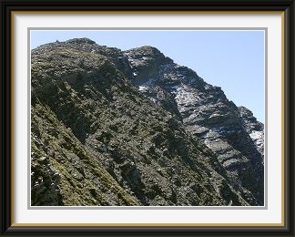
We started with a mistake by following the numerous signs for the peak within the village; we would have been better off instead to have looked for the first hamlet listed in the guidebook. To avoid carrying the extra weight, I had memorised the relevant route description, so I was puzzled that the trail didn't correspond to my expectations. Rather in the manner of the curate's egg, this path was well marked in many parts. We had to guess our way across a couple of roads before following some marker poles up a grassy slope. Soon there were no more markers visible, but the direction had been clear, so we pressed on upwards on steep grass. About a hundred metres higher it was obvious that, wherever the track was, we weren't on it. A traverse across cow pasture fixed that; however, we still weren't on the guidebook path, and now we had acquired a herd of placid goats who followed us up the mountain for a remarkably long time. Finally we did encounter a signpost mentioned in the guidebook, but by this time the route to the summit was obvious anyway. Above 1900 metres, the tedious grass gave way to a stony ridge, which continued all the way to the summit, a fine viewpoint across the nearby Lauenenhorn to the Wildhorn and the main Bernese Oberland chain. The cairn fairy had been at work here too. All that fooling around lower down had cost time, however, and my time to the summit was a full half hour slower than the signpost time, an occurrence so rare I couldn't remember when it had last happened. The WF was even worse, arriving another thirty minutes later, so plans to continue further were abandoned, and we spent a luxurious couple of hours at the summit in near-perfect weather. While the 4000-metre peaks were partly obscured by cloud, there were fine views of Gstaad's manicured alpine pastures and of numerous Fribourg prealps like the Dents de Folliéran and Brenleire. Going down the way we had come up, we were able to find the track intended by the guidebook (more tedious hardly-trodden grass), and we returned to Gstaad through Oberbort and its monster chalets.

The Stockhorn Chain has its western end somewhere to the east of the Gantrisch and extends through the Stockhorn itself eastwards to the Simmenfluh at the entrance of the Simmental. It forms the backdrop to many pictures of Thun. Walking tracks traverse the southern slopes of the chain for most of its length.
 A string of warm late-summer days was drawing to an end and I decided to get out
before the weather turned. With the arrival of rain a possibility
later in the day, it was wise not to go too high. As I was relatively late
starting also, I decided to make a conservative choice and do something in
the Stockhorn chain. Given that I had done the two main peaks so often, it
needed to be something else, but what? Well, a well-defined path exists
between those two peaks, so, even though they are more than seven Km. apart
in a straight line, the return journey from the usual starting point for the
Gantrisch looked worthwhile.
A string of warm late-summer days was drawing to an end and I decided to get out
before the weather turned. With the arrival of rain a possibility
later in the day, it was wise not to go too high. As I was relatively late
starting also, I decided to make a conservative choice and do something in
the Stockhorn chain. Given that I had done the two main peaks so often, it
needed to be something else, but what? Well, a well-defined path exists
between those two peaks, so, even though they are more than seven Km. apart
in a straight line, the return journey from the usual starting point for the
Gantrisch looked worthwhile.
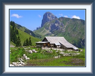
I parked the car in the usual spot near the Gurnigel and set off up what is for me a very well-trodden path indeed. Just beyond the little Schibespitz and its crumbling army pillbox, I turned away from the last short stretch to the summit of the Gantrisch in favour of the long traverse to the Stockhorn, on the extreme right in the photo. The path stays high on the sides of the intervening peaks, passing through a series of alpine pastures. Some of the work to clear the path near the chalets looked almost like the start of a rock garden. In other places, it was just a pleasant track through the uppermost scraps of forest, never dif ficult. At the little alp of Kuhlauenen, the view of the peak was already much better. Only the final ascent of the Stockhorn's rocky summit tower was at all strenuous. From there, the view back to the Gantrisch (the rounded and tilted summit at centre) can be seen, as well as much of the trail.
On the long walk back, the sky was becoming duller and rain threatened, so I skipped the bit across the Schibespitz and the Morgetepass and cut across the Leiterenpass between the Gantrisch and the Nünenen, a quicker route back to the road and the car. The latter peak, to the right of the pass in the photo, is at the outer limits of walkability and I haven't tried it yet; people do get killed there occasionally.
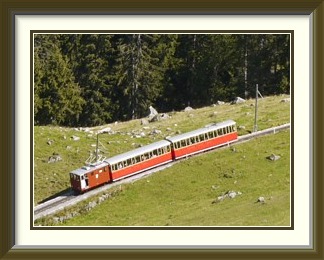
Schynige Platte is the terminus of a cog railway from Wilderswil, but a perfectly acceptable track makes the same ascent, only occasionally crossing the railway. Easy tracks lead from the station complex to the nearby and slightly higher Oberberghorn. Expect crowds around the complex, but relative solitude on the track up, as almost everyone takes the train!
 The next walk was an exception, in that the date was fixed. A Running Friend
was doing the Jungfrau Marathon
on the eleventh of the month. This wasn't something I would ever try; my back might
not stand the amount of running on asphalt involved in the early stages, but the
RF's family owned a chalet almost beside the route in the Lauterbrunnen Valley,
and I intended to be there for the party afterwards. I didn't want to walk in
the direction of the finishing line in Kleine Scheidegg; it had been
crowded and tawdry the previous year. That left just one good choice, the path
on the hill behind the chalet leading up to Schynige Platte, so I
dropped my stuff off at the chalet and went back down to start the walk at
Wilderswil. I was late enough starting that this meant walking down the road
against the runners. Nobody
seemed to mind.
The next walk was an exception, in that the date was fixed. A Running Friend
was doing the Jungfrau Marathon
on the eleventh of the month. This wasn't something I would ever try; my back might
not stand the amount of running on asphalt involved in the early stages, but the
RF's family owned a chalet almost beside the route in the Lauterbrunnen Valley,
and I intended to be there for the party afterwards. I didn't want to walk in
the direction of the finishing line in Kleine Scheidegg; it had been
crowded and tawdry the previous year. That left just one good choice, the path
on the hill behind the chalet leading up to Schynige Platte, so I
dropped my stuff off at the chalet and went back down to start the walk at
Wilderswil. I was late enough starting that this meant walking down the road
against the runners. Nobody
seemed to mind.
The ascent is just a little over 1400 M. and it's through pine forest much of the way, so the main attraction was the exercise. Nevertheless, there is a short stretch of open ground with a fine view over Lake Thun from above the chalet at Schönegg, plus the occasional sight of the cutesy little Schynige Platte train heaving yet another set of customers up the hill. The uplands behind the railway and restaurant complex are a paradise for tourists, but not the worse for that, as there is plenty of space for everyone. A mountain trail leads east past the Laucherhorn (on the left) and the Winteregg to the Faulhorn and First and all the way down to Grindelwald. The whole trip from Wilderswil makes a splendid long day for those in condition. Today, however, was for wandering around the high meadows in the sunshine and going up the little Oberberghorn for the panoramic view down to Lake Brienz and up to the Oberland Peaks; a ladder is needed to reach the summit, so this bit might reasonably be classed as grade T3 unlike the rest of the day. There was time for a beer in the restaurant by the railway terminus before taking the same path down just in time to meet the RF arriving back at the chalet from another successful marathon run.
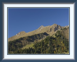
Steinschlaghorn, Tschipparellenhorn and Mäggisserenhorn are three consecutive peaks in the Niesen Chain, a long ridge which begins at the Niesen summit and extends in a relatively straight line above 2000 M. as far as the Albristhorn west of Adelboden, a distance of more than twenty Km. dotted with interesting summits all the way.
 This walk is ideal for those without their own transport, since it starts
and ends at the Frutigen railway station car park, which lies at the foot
of the three peaks involved.
This walk is ideal for those without their own transport, since it starts
and ends at the Frutigen railway station car park, which lies at the foot
of the three peaks involved.
Routefinding isn't a problem at first... simply head straight for the rightmost of the three peaks directly above the town, the Steinschlaghorn (2321 M.) on farm roads and fairly well marked tracks. Above Gunggstand the path becomes poorly formed on steep grass slopes, and care is necessary. The Steinschlaghorn summit is the least pronounced of the three, but an adequate spot to stop for a snack. From it, a marked route (blue and white markers) runs along the ridge to the Tschipparellenhorn (2398 M.), the highest point of the tour. While marked as a route rather than a trail, it is perfectly safe for competent walkers, the only aid being a piece of cable to help in crossing a notch at the summit. From here, as from all three summits, there is a fine view down to your starting point a mile below. Also visible is the old Lötschberg railway line curving elegantly over the northern portal of the new Lötschberg Base Tunnel and crossing the Kander river on the original stone arch bridge and a newer concrete structure. Though overcast by this stage, the weather remained fine and calm. After a brief stop, the route continues below the crest on the western side to approach the Mäggisserenhorn (2348 M.), whose grassy summit was badly fouled by the droppings of the flock of goats visiting from the slopes between it and the Tschipparellenhorn. From here, the path was a marked walking track once again, which continued a little further along the crest before making a dogleg down more iffy grass slopes. It then became, by the high standards of the Bernese Oberland, quite unpleasant, dispensing with hairpins and heading straight down the steep alpine pastures, in many parts barely discernible in the grass, with sporadic markers often hidden by the contour until you were nearly on top of them. After about eight hundred metres of this knee torture, more normal conditions resumed, and the three peaks were still visible as I descended through the outskirts of Frutigen.
Thus was completed the last successful walk of a relatively modest year.