


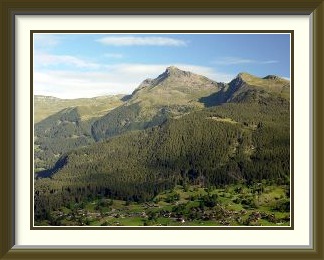
The Sigriswiler Rothorn is a limestone mountain in the Emmental Alps to the northeast of Sigriswil. It overlooks the quiet and scenic Justis Valley and is prominently visible across Lake Thun from the highway to Interlaken.
 We had arrived back in Switzerland only in the last days of July. There
are few nicer ways of getting to Burgdorf than collecting the rental
car in Milan and driving the Gotthard motorway across the Alps, with
frequent coffee stops at the excellent service stations to keep you
on your toes after the long flight from Hong Kong.
August began with a period of muggy and rather cloudy weather, so
I dismissed the tradition of starting with the
Gantrisch
and instead did a quick eight ascents of
the local hill
while the views were rubbish. They were still looking a bit rubbishy a few
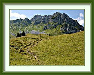
days later when I set out for the Sigriswiler Rothorn (which looks like
this
on a sunny day). From the hamlet of
Sagi
behind Schwanden on the terraces to
the north of Lake Thun, the ascent is just under a thousand metres,
perfect for a starting walk. From Sagi, the peak is part of a long ridge
stretching southward; two paths cross to the other side of this ridge on the
way to the summit, the higher of which I chose for the ascent. At Bodmi,
the uppermost chalet peered down
through the mist at Lake Thun before the path left
the alpine meadows behind and entered the forest.
Immediately after crossing the ridge, the path veers northeast and enters a
rather enclosed landscape of pines and boulders. This has an almost
garden-like quality at times, especially around the
chalet at Oberbergli.
We had arrived back in Switzerland only in the last days of July. There
are few nicer ways of getting to Burgdorf than collecting the rental
car in Milan and driving the Gotthard motorway across the Alps, with
frequent coffee stops at the excellent service stations to keep you
on your toes after the long flight from Hong Kong.
August began with a period of muggy and rather cloudy weather, so
I dismissed the tradition of starting with the
Gantrisch
and instead did a quick eight ascents of
the local hill
while the views were rubbish. They were still looking a bit rubbishy a few
days later when I set out for the Sigriswiler Rothorn (which looks like
this
on a sunny day). From the hamlet of
Sagi
behind Schwanden on the terraces to
the north of Lake Thun, the ascent is just under a thousand metres,
perfect for a starting walk. From Sagi, the peak is part of a long ridge
stretching southward; two paths cross to the other side of this ridge on the
way to the summit, the higher of which I chose for the ascent. At Bodmi,
the uppermost chalet peered down
through the mist at Lake Thun before the path left
the alpine meadows behind and entered the forest.
Immediately after crossing the ridge, the path veers northeast and enters a
rather enclosed landscape of pines and boulders. This has an almost
garden-like quality at times, especially around the
chalet at Oberbergli.
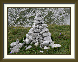
On the final stretch to the summit, the path traverses an area of Schrattenkalk, limestone eroded into grooves. A short step here needs use of the hands and is the only part of the walk requiring a T3 rating. Sadly, the clouds were still in attendance and most of the views from the summit were downwards. Plentiful local supplies of limestone made life easy for the cairn fairy here!
On the way down, I chose the lower path from their meeting point at Oberbergli. The garden scenery was followed by more open grass slopes, where the clouds parted to reveal the neighbouring Niederhorn and its telecoms tower. Nearing the ridge, this path became a mud bath in places, though the damp conditions made for some almost tropical lushness on the way. If you don't mind the risk of mud, the path is perfectly OK, but the upper one is faster and would probably be the preferred choice for most walkers.

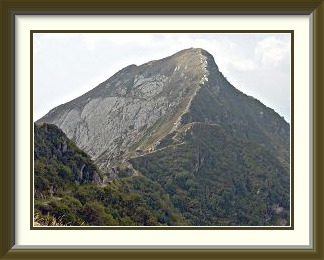
The Widdersgrind ("Ram's head") is a mountain in the Bernese Prealps to the north of the village of Oberwil in the Lower Simmental. It can be approached from several alpine valleys; the approach from the south described here is the steepest.
 A couple of cool, rainy days had passed and the sun was out again. A peak
low enough to have dried out quickly would make for pleasant walking, and
the Simmental was one place with no shortage of these. The choice fell on the
Widdersgrind,
which had the added advantage of being one I hadn't walked before. The
quickest access is from the hamlet of Oberwil; like many villages in the
Simmental, Oberwil is full of lovely traditional chalets.
As almost everywhere in Switzerland however, a tangle of electric wires
prevented most of them from being photographed,
this one
being a pleasant exception.
A couple of cool, rainy days had passed and the sun was out again. A peak
low enough to have dried out quickly would make for pleasant walking, and
the Simmental was one place with no shortage of these. The choice fell on the
Widdersgrind,
which had the added advantage of being one I hadn't walked before. The
quickest access is from the hamlet of Oberwil; like many villages in the
Simmental, Oberwil is full of lovely traditional chalets.
As almost everywhere in Switzerland however, a tangle of electric wires
prevented most of them from being photographed,
this one
being a pleasant exception.
I parked the car in the space by the railway station, the only obvious possibility in Oberwil's constricted hillside location. The ascent began in the nicest possible way, up a steep sylvan path climbing rapidly in the shade. After an hour and a half, I had gained 750 metres, and a little later reached the end of an alpine road, where it was time to leave the marked path and use the south ridge to reach the summit. After an initial stretch up the Holzmad Alp, the ridge steepened below the summit block. I had been looking forward to the crux of the walk, the Widdergrind's summit rocks, rated as T4+ in my walking guide for the area1, but it turned out to be a comfortable jumble of rocks and grass, steep enough, but only just requiring the use of the hands for balance here and there; thus the rating given above.
The summit panorama to the southeast included the Holzmad Alp, the Lower Simmental and the Bernese Oberland peaks. The northern slopes were far gentler, and provided space for a profusion of flowers, probably because cattle didn't seem to have access. As the intent was to traverse the mountain, descent was by the marked path northwards and a circuit of the peak on somewhat scrappy tracks through various alpine meadows. The little Schattigseeli provided a scenic moment, and on the approach to the roadhead there was a fine early evening view of the peak before the long descent to Oberwil.
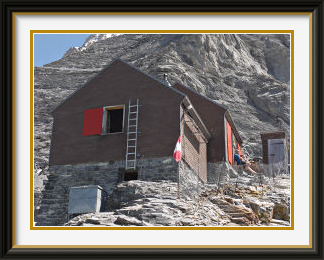
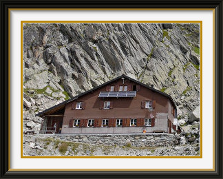
The Guggi Hut belongs to the Interlaken Section of the Swiss Alpine Club. It is perched on a rocky promontory in the middle of the western cliffs of the Mönch and is the starting point for the challenging "Nollen" route up that mountain.
 A run of fine days since the last walk was coming to an end, so it was
time to do something more difficult while conditions remained
excellent. That would normally be a summit, but there was one hut
with a fairly rough approach which I had never tried, the
Guggi Hut.
On its remote perch above the tourist anthill of Kleine Scheidegg,
it should present some interesting contrasts, at least. To make it
a strenuous day (and to avoid using mechanical means of ascent), it
would be necessary to walk from Grindelwald.
A run of fine days since the last walk was coming to an end, so it was
time to do something more difficult while conditions remained
excellent. That would normally be a summit, but there was one hut
with a fairly rough approach which I had never tried, the
Guggi Hut.
On its remote perch above the tourist anthill of Kleine Scheidegg,
it should present some interesting contrasts, at least. To make it
a strenuous day (and to avoid using mechanical means of ascent), it
would be necessary to walk from Grindelwald.
So it was that I parked the car in Grindelwald Grund; at 943 metres, that gave me an ascent of 1850 to do. The thousand metres of ascent over easy tracks to Kleine Scheidegg provided few opportunities for photography, with the Eiger's north face towering so extremely over the track that only technical camera lenses could do it justice. Once at the Scheidegg, the views for which it is justly famed abruptly opened out. On a clear summer morning like this, the Jungfrau's huge northern flank presents itself so starkly that one feels like telling the scenery that there is no need to shout. Perched high on a rocky promontory in front of the Jungfraujoch buildings on the skyline, the hut is too small to make out easily from this point. From the Scheidegg, the route continues up the last of the easy tourist trails leading to an old moraine of the Eiger Glacier at the foot of the precipices on which the hut lies.
Unfortunately, the "real" walk then begins with a descent of about a hundred metres to a point where you meet the outflow of the glacier, surprisingly modest and easy to cross despite the warm weather. Having regained those lost metres, you can look steeply up at the route ahead. The hut is on the promontory on the right; on the left are the summit slopes of the Mönch, which this hut was built to serve. The rest of the walk is over wild, rough ground, with occasional steps to be climbed and lots of loose scree. There is barely space for the hut on its steep and narrow ridge, but the views are correspondingly awesome. There's an unfamiliar side of the Eiger for one thing, and a panoramic view of the tourist wonderland of Kleine Scheidegg and Eigergletscher at your feet. On such a fine day, it's a great place to munch your sandwiches hundreds of feet above the seracs of the Guggi Glacier almost vertically below you.
The Gsür is a mountain in the Bernese Alps near Adelboden. It lies near the southwestern end of the long Niesen Chain and is the second highest of the Chain's numerous summits.
 The poorer weather forecast after the last walk hadn't amounted to
much more than a few thunderstorms in the mountains. With the
return of mostly sunny days, conditions were right for a more
demanding walk. While I had done a number of excursions
from Adelboden over the years, most were at the T2 level. I had
also been up the slightly harder Albristhorn, but its
neighbour the Gsür had always looked too difficult. No marked
path leads to the summit, and there wasn't that much about it on the
usual websites; nevertheless I gleaned enough information to give it
a try.
The poorer weather forecast after the last walk hadn't amounted to
much more than a few thunderstorms in the mountains. With the
return of mostly sunny days, conditions were right for a more
demanding walk. While I had done a number of excursions
from Adelboden over the years, most were at the T2 level. I had
also been up the slightly harder Albristhorn, but its
neighbour the Gsür had always looked too difficult. No marked
path leads to the summit, and there wasn't that much about it on the
usual websites; nevertheless I gleaned enough information to give it
a try.
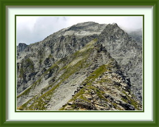
From the centre of Adelboden, easy paths led to the top of the Tschentenalp cable car and the start of a popular track across the southern slopes of the mountain called the Gsürweg. From here, the route up the Gsür's SE ridge was already visible. With the marked track left behind, the going got a little rougher before a long couloir led all the way to the summit ridge. Getting there wasn't the end of the fun, though, as a look at the surprisingly interesting summit ridge showed. On closer acquaintance, the main step on the ridge didn't disappoint, and there was a chance or two to get some air under your shoes. Rising summer cumulus along the whole southeast aspect of the Niesen Chain left just half the view at the summit cairn and cross, but there was so much general interest that I didn't mind. Close by, for example, lay the striking Türmlihorn, and there was a fine perched slab waiting for the day of its inevitable fall towards the Färmel Valley below.
The cloud had thickened a little by the start of the descent, hiding some of the views of the Gsür's magnificent slate precipices and the sun was gone on the last of the path down to Adelboden.
As information about this walk is relatively hard to come by, especially in English, a guide follows for anyone trying to turn this page into practice.
WALKING THE GSÜR FROM ADELBODEN
From the tourist office in the town centre, cross the road and walk a short distance to the Tschentenalp lift. Take it or follow the road around a sharp bend to the R and then up the hill until you see the first Wanderweg signpost. Follow a pleasant, easy path to Tschentenegg and a jeep track to the upper lift station. Now follow the blue signposts for the Gsürweg, a track which traverses the southern slopes of the mountain, past the minor viewpoint called the Schwandfeldspitz. When a last blue signpost points across the slope, leave the Gsürweg and head up the still wide grassy ridge on traces of a path. After about twenty minutes, the ridge sharpens and the track continues, at times a little vertiginously, along the apex of this and over a few small steps. Further up, the way looks as if it is blocked by small conical mounds of shaly rock. Don't be put off... the path skirts these expertly and becomes better defined as it hairpins up the steepest grass. Keep going until the very last bits of grass and thistles; you are there when the way forward is barred by a wall of the same shaly rock.
Now sidle a modest distance left across loose, stony slopes into a couloir which leads all the way to the summit ridge. Warning: you are entering a long couloir at an arbitrary point in its middle. Leave a brightly coloured object or flag under a stone here to let you know when to leave the couloir on the way down if mist descends. Exit too soon, and you will face vertical drops; too late, and you will quickly be lost on trackless and dangerous slopes. Warning 2: the stones lying around in the couloir are very sociable... send one on a journey to the valley, and scores of its friends will join it for the trip! So, if there is a party already in the couloir, give them plenty of time (at least twenty minutes) to exit it before you enter. Apply the same principle on the descent.
I ascended the bottom of the couloir, which seemed to be an exposed dyke of harder rock giving a slightly sounder footing. The upper exit is on the summit ridge, where you already have a fine view to the west. The ridge is as steep and exposed as the photos above suggest. Stay on the ridge all the way to the summit, about fifteen minutes if you are taking your time, which you should be doing unless you are used to this kind of terrain. The summit book is in the furthest of the two cairns, the one with the cross. Return the same way; continuing along the ridge to the saddle called the Furggeli is more difficult.
The Reeti (also Rötihorn) is a mountain in the Bernese Alps near Grindelwald. It can be walked directly from Grindelwald, or the journey can be shortened by taking the gondola to First. Though it lies in a very busy hiking area, it is itself little frequented.
 In contrast to its usual practice, the weather threatened to be so
good that walking would be impossible... a late summer
heatwave loomed, where even the summits would fail to refresh and
afternoon descents would turn into sauna sessions. The day before
the heatwave arrived, I was in Grindelwald in time for a
reasonably early start for one of the relatively few peaks above
the town which doesn't have an official path all the way to the summit,
the Reeti.
In contrast to its usual practice, the weather threatened to be so
good that walking would be impossible... a late summer
heatwave loomed, where even the summits would fail to refresh and
afternoon descents would turn into sauna sessions. The day before
the heatwave arrived, I was in Grindelwald in time for a
reasonably early start for one of the relatively few peaks above
the town which doesn't have an official path all the way to the summit,
the Reeti.
As mentioned elsewhere, getting up the hill out of Grindelwald quickly can be a problem at times, but right opposite the train station, the path towards the Aellfluh (...fluh meaning precipice in Swiss German) wasted no time gaining height. No problem following the route on my older Eastern Bernese Oberland walking map dated 1984, where it appears as the "Ällflue", but what would the visitor make of the version on the 2009 Interlaken walking map, "Ällflüö"? Both of these are just annotated versions of the 1:50000 LK series; it's there that the "improvements" (conversion into local dialects/pronunciations) are being made and they extend to much more significant landmarks. The nearby Schwarzhorn has morphed into the "Schwarzhoren" in the newer map, for example. Go just thirty kilometres west, however, and the Elsighorn near Frutigen on the 1984 map has become the Elsighore on recent editions. The Swiss Landeskarten are way up there alongside the British Ordnance Survey maps as the best national maps in the world, and I don't think they are enhanced by this sort of tomfoolery.
Not far above the Aellfluh restaurant, the track reached a surfaced road and the only level stretch to Holewang. Not much more than an hour above Grindelwald, the area felt remote and there were no walkers. Another hour or so the trees were left behind and the track ascended the slopes of grass and boulders leading to the saddle called the Hireleni. At least, that's what it was called in various places on the Web, but the solitary signpost to it, already at about 2000 metres, called it the Hireli. Here the track briefly followed a much more popular path, one of the many radiating from the First cable car station, before forking off and becoming unmarked and at times vague. Soon the first good view of the summit appeared, and it was not long until I was there.
Being one of the tallest peaks north of Grindelwald, there are the usual panoramic views of the Oberland giants, but of more interest was a new perspective on the Schwarzhorn group. Along the ridge from the Reeti was the Simelihorn, which looks rather like some dessert over which chocolate sauce has just been poured! There's a fine view of the Bachalpsee and the hikers' motorway between First and the Faulhorn running alongside it. The lake is justifiably famous for its backdrop of Oberland 4000ers and features on many a Swiss calendar.
Monte Tamaro is a mountain in the Lugano Prealps. With no higher peaks anywhere nearby, it commands magnificent views in all directions, particularly towards the main Alpine range to the north.
 I had gone south of the Alps to Locarno as the mid-August heat
wave was coming to an end, and there were
just hours before a cold front displaced the warm air in a blaze of
thunderstorms. I needed a peak with a lift in service in case I had to
get down quickly; Monte Tamaro across Lake Maggiore looked about right.
Starting from Rivera on the Autobahn to Lugano, the
Alpe Foppa lift
would cover the last thousand metres of the descent, and the paths
near the summit would be safe even in rainy conditions.
I had gone south of the Alps to Locarno as the mid-August heat
wave was coming to an end, and there were
just hours before a cold front displaced the warm air in a blaze of
thunderstorms. I needed a peak with a lift in service in case I had to
get down quickly; Monte Tamaro across Lake Maggiore looked about right.
Starting from Rivera on the Autobahn to Lugano, the
Alpe Foppa lift
would cover the last thousand metres of the descent, and the paths
near the summit would be safe even in rainy conditions.
Of the thousand metres of track from the lift's (free) car park to Alpe Foppa, the less said, the better. The tedious ascent up jeep tracks and bits of path was a sauna in the morning heat as it zigzagged under the string of cabins heading up the hill. On this southern side of the Alps, the forest was drier and there were more lizards rustling in the undergrowth; it was only after Alpe Foppa had been left behind that the track acquired a more familiar Alpine feel as it skirted a big telecoms tower and followed a grassy ridge upwards. Here was the first good view of the summit, which is concealed for most of the way. On top at last, there was a strong heat haze blotting out distant peaks, but Locarno and Lake Maggiore were visible more than a mile below. Nice to see that the Cairn Fairy does the Italian part of Switzerland too!
Seven years earlier, there had been fewer problems with haze and the mountain's magnificent panorama had been fully visible. As well as Locarno, the other major towns in the region could be seen, Lugano to the south and Bellinzona below Alpe Foppa to the east. Far to the west, Monte Rosa and the Valaisian Alps filled the horizon beyond the rugged hills of Northern Italy.
Despite the threatening weather, the cloud did not descend while I was at the summit, but back at the upper lift station the sky was darkening and the decision to take the lift was easy. An hour later, a ninety-minute squall struck Locarno and its environs. Walking down would not have been fun!
The Schreckhorn Hut belongs to the Basel Section of the Swiss Alpine Club. It has perhaps the most spectacular location of any walkable hut in the Swiss Alps. Its views are of the highest ice peaks of the Bernese Oberland, with the lowlands almost completely out of sight.
 Anyone taking even a casual look at walking maps of the Grindelwald area
will quickly notice that just one path penetrates far into the world of
ice and rock which is the core of the Bernese Oberland. The path to the
Schreckhorn Hut
may not have the grand, open views of a summit ascent, but it is nonetheless
one of the most magnificent tracks in the Bernese Alps, providing
novel views of familiar peaks like the Eiger and Mönch and being the
walker's only way of getting near the Oberland's highest summit, the
Finsteraarhorn. It's also a showcase for the damage being done to so many
parts of the Alps by the melting of the glaciers.
Anyone taking even a casual look at walking maps of the Grindelwald area
will quickly notice that just one path penetrates far into the world of
ice and rock which is the core of the Bernese Oberland. The path to the
Schreckhorn Hut
may not have the grand, open views of a summit ascent, but it is nonetheless
one of the most magnificent tracks in the Bernese Alps, providing
novel views of familiar peaks like the Eiger and Mönch and being the
walker's only way of getting near the Oberland's highest summit, the
Finsteraarhorn. It's also a showcase for the damage being done to so many
parts of the Alps by the melting of the glaciers.
A day beginning with blue skies had cloud and light rain forecast for mid afternoon, so I was up early to drive the hundred or so kilometres to Grindelwald and get on the path by eight. After the obligatory stint through the woods, the path runs south above the gorge of the Lower Grindelwald Glacier, at this point long devoid of ice. On more open ground below the new Bäregg Hut, there is a view across the chasm to a pile of rubble at the foot of a cliff. This is all that remains of a nose of rock, a low shoulder of the Eiger, which broke off the rest of the mountain as the ice around it receded and no longer provided support. Several million tons of rock didn't go all at once, but in a myriad of small avalanches over months. This is what it looked like as it began to slump in July 2006.
A short distance further along the path, there is a view back to the Bäregg Hut on its elevated site. It's there because it replaces the old Stieregg Restaurant, which once occupied the small grassy terrace in the bottom centre of the picture. The track, long closed, which led to the restaurant can be made out along the sheer promontory in the background. I still have a clear recollection of rounding that promontory in the late 1970s to see, half framed by overhanging rock, the busy restaurant on its pretty terrace. Sadly, I did not take a photograph. This fragment of foundation is all that remains of the Stieregg now; it once had eighty metres of land in front of it, but virtually the whole of the terrace has fallen into the void left by the retreating ice. Below is the glacial lake dammed by the debris from the collapsed cliff. Yet more work for the authorities... a drainage tunnel had to be dug through the mountain to empty it before it burst of its own accord and caused mayhem in Grindelwald.
Finally the track rounds a corner at the Bänisegg and turns eastwards, leaving the landslides behind and opening up entirely new views. The Mönch appears above a tangle of iceflows, and the icefall from the Oberes Eismeer looms ahead. The cliffs to the left of this are the main challenge of the walk and require chains and ladders for a time. Above these on the last stretch to the hut, there are fascinating views of the tangle of seracs just below the track as the Finsteraarhorn and the Agassizhorn come fully into view.
Arrived at last at the Schreckhorn Hut below the mountain it serves, you can rest in the middle of perhaps the most spectacular setting a walker can get to in the Oberland.
It was even better once. The first time I walked this track, it skirted the promontory where the Schreckhorn Hut now lies and descended onto the flat surface of the Oberes Eismeer. In summer, the glacier was snow-free and the crevasses were easy to avoid. Encountering a large boulder, I was unable to resist temptation and worked for some minutes to push the stone to the edge of a nearby crevasse. When it finally slid over the edge, there was a moment of silence before a splintering crunch as it struck a projection. More silence was followed by a very satisfying boom as the mass of rock and ice hit the pool of meltwater far below. The track finally left the ice once more and ascended a rock slope to the Strahlegg Hut at 2688 M. and its even closer view of the Finsteraarhorn. This spectacular hut had been fatally damaged by an avalanche months before I reached it in 1977, although the damage is not obvious in the photograph. It was finally abandoned in 1980 to make way for the new Schreckhorn Hut.