


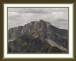
The Seehorn is a mountain in the Bernese Prealps. It lies between Grimmialp in the Diemtigtal Valley and Zweisimmen in the Simmental. It is approached by a somewhat circuitous route from Grimmialp.
 The year started off with more snow falling on the Alps than had been
seen for decades, then a long, cold spring was followed by warmer than
average summer conditions. It would be interesting to see whether
old snow was still affecting tracks higher up.
Casting around for a starting point, I chose the Diemtigtal, a valley
of relatively modest elevations; one of its peaks, the
Seehorn, looked rough
enough to be interesting.
The year started off with more snow falling on the Alps than had been
seen for decades, then a long, cold spring was followed by warmer than
average summer conditions. It would be interesting to see whether
old snow was still affecting tracks higher up.
Casting around for a starting point, I chose the Diemtigtal, a valley
of relatively modest elevations; one of its peaks, the
Seehorn, looked rough
enough to be interesting.
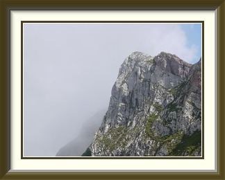
From my parking spot, it lay to the southwest in the morning sunshine, and the path proceeded westwards at first to skirt its wooded slopes. So far, so normal, but then it did something surprising... it turned north away from the Seehorn as it began to ascend steeply through pine forest. An hour or so later, the peak was further away than ever as the path finally came out onto easy grass uplands above the circular band of cliffs which had blocked direct access to the mountain. Even now it still wasn't heading for the peak, but gradually the curve of the cliffs brought it around as it approached the pretty Seeberg Alp, with its restaurant well frequented via a road up another valley. From here, the top was in plain sight, but the rest of the way up is not an official Wanderweg and there were no signposts or markings telling me where to go next.
Once I had found the start of the route up the peak proper (see below), sporadic non-standard markings in red paint resumed. This is a classic karst mountain, and from here the smooth knuckles of limestone protruded everywhere into the path and made walking harder. At first, the way was half hidden in low bushes, but soon the vegetation became sparser; as the summit appeared, the mountainside was almost entirely stony. The cairn fairy had done the usual work on top alongside another object of indeterminate utility. Cloud had lifted off the peak, and there was a fine view down to Schwanden and the car park where I had started.
FINDING THE START OF THE ROUTE UP THE SEEHORN
From the Seealp restaurant chalet, continue on the main track to the Seealpsee. Turn left at a chalet after roughly two hundred metres. Pass this chalet and ignore a farm track heading off to the right. Instead continue straight along a less well defined track winding gently downhill; this is at first not much more than grass worn by farm machinery, but soon becomes clearer. After about ten minutes an unmarked walking path turns off to the left towards the peak. Follow this for another five minutes or so to the first karst outcrops and the first markings (red arrows) at the start of the route.

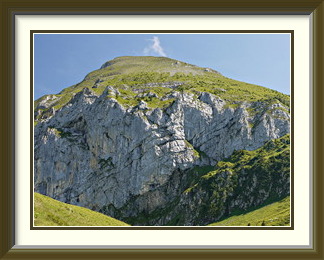
The Morgenberghorn is a mountain on the southern shore of Lake Thun in the canton of Bern. It is prominently visible from the highway to Interlaken. Of its three ridges, two are straightforward walks and one, the northeast, is extremely dif ficult.
 Since the last walk, a weakening cold front had come to Switzerland to
die, and high pressure was back in place after no more than a few
showers to the east. Looming over the shores of Lake Thun on the
approach to Interlaken, the Morgenberghorn has lake and mountain views
almost on a par with those of the
Niesen nearby.
Having done this peak from the slightly easier approach up the Saxetal
a couple of times in the Eighties, I decided to try it for the first
time from its western side. Accordingly, I turned off the motorway at
Spiez and drove to the start of the little Suld Valley beyond the
village of Aeschiried. Despite its being no more than two kilometres
as the crow flies from the main highway to Interlaken,
I could not remember ever having driven through Aeschiried before.
How many more places like this have I missed?
Up the narrow, locally-maintained road through the valley itself, the
parking place at the Pochtenfall Restaurant was the ideal starting
point for the mountain.
Since the last walk, a weakening cold front had come to Switzerland to
die, and high pressure was back in place after no more than a few
showers to the east. Looming over the shores of Lake Thun on the
approach to Interlaken, the Morgenberghorn has lake and mountain views
almost on a par with those of the
Niesen nearby.
Having done this peak from the slightly easier approach up the Saxetal
a couple of times in the Eighties, I decided to try it for the first
time from its western side. Accordingly, I turned off the motorway at
Spiez and drove to the start of the little Suld Valley beyond the
village of Aeschiried. Despite its being no more than two kilometres
as the crow flies from the main highway to Interlaken,
I could not remember ever having driven through Aeschiried before.
How many more places like this have I missed?
Up the narrow, locally-maintained road through the valley itself, the
parking place at the Pochtenfall Restaurant was the ideal starting
point for the mountain.
Barely half an hour up the track (one of two choices to the peak), I emerged suddenly from the forest into the little alpine meadow at Louwene, resplendent in the morning sunshine. Here the track turns more steeply away from the river and hairpins its way to the highest alpine chalet on the route at Brunni. Above Brunni, there are more hairpins with lake views. The going had been easy so far, but shortly afterwards there is a short, steep stretch with chains through a band of cliffs guarding the mountain on this side. It is this stretch alone which requires the T4 rating. Further up the loose, stony path, there is a brief glimpse of the first hairpins out of Louwene far below.
There was no cairn fairy work on this summit, but an outburst of patriotism instead, all the more striking for its rarity. In a country where private properties seem to sport the national flag everywhere, you almost never see them on summits. From the comfort of the bench, I could look down on Lake Thun and waterside villages like Leissigen, with its trains going to and from Interlaken.
After descending to Brunni, I took a different path the rest of the way back to the car. Just below Brunni, there is a fine view back to the Morgenberghorn and its band of cliffs.
The Outer Fisistock is a mountain between Kandersteg and the Gastern Valley in the canton of Bern. Its near-vertical northern cliffs are visible from the road to Kandersteg. Access from the road is via the Fisialp and the entirely stony Brünnli Valley.
 The first two walks having exposed no physical problems, it was time
to try something a little harder. Quite a few of the longer walks in the
Bernese Oberland I had done relatively recently, but there was one that
had lain fallow for twenty years. The Outer Fisistock looms darkly
behind Kandersteg as a set of near-vertical precipices, and would seem even
bigger from the resort if it were not dwarfed by the glaciated Doldenhorn
and the Blümlisalp peaks. Driving through Kandersteg a few days
before the walk, I spotted the hotel where I had parked so conveniently
long ago, right beside the start of the path. Then, the parking places had
been hidden in trees some distance away from the main building and I had
been confident nobody would notice; now, smart new chalets had replaced the
trees, but the parking places were still there. To avoid unpleasantness,
I went to reception to ask what it might cost to park on their grounds for a
day. No problem, said the friendly lady, just don't use the covered spaces
(of which there were only a few), and nobody would mind.
The first two walks having exposed no physical problems, it was time
to try something a little harder. Quite a few of the longer walks in the
Bernese Oberland I had done relatively recently, but there was one that
had lain fallow for twenty years. The Outer Fisistock looms darkly
behind Kandersteg as a set of near-vertical precipices, and would seem even
bigger from the resort if it were not dwarfed by the glaciated Doldenhorn
and the Blümlisalp peaks. Driving through Kandersteg a few days
before the walk, I spotted the hotel where I had parked so conveniently
long ago, right beside the start of the path. Then, the parking places had
been hidden in trees some distance away from the main building and I had
been confident nobody would notice; now, smart new chalets had replaced the
trees, but the parking places were still there. To avoid unpleasantness,
I went to reception to ask what it might cost to park on their grounds for a
day. No problem, said the friendly lady, just don't use the covered spaces
(of which there were only a few), and nobody would mind.
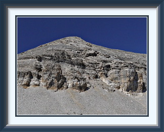
Duly parked on the day, I set off up the first part of the walk, a relatively unexciting ascent of eight hundred metres mainly through steep forest to the Fisialp. The next target was the high valley called the Brünnlital, reached via the gap diagonally across the Fisialp in the picture. As there is no recognised walking route on the Fisistock, I chose my own route to the entrance to the Brünnlital, where a faint path led up the last of the grass. After a couple of rock steps, the Brünnlital opened out, a world of steep rubble fringed by a band of low cliffs. I ignored a few random cairns and headed for the cliffs, where the scree was almost at its critical angle; at times the entire slope around me moved a little with every step, and progress was exhausting. Fortunately, access to the upper terrace could be gained via a notch in the cliffs, a welcome break also from the endless slog up the scree.
The upper terrace levelled out onto a saddle from which there was a good view to the summit of the Fisistock, and just above the saddle the size of the rubble at last decreased to the point where the occasional walkers left a detectable impression (visible in the centre of the picture), making the rest of the way obvious. On the wild and shattered summit, there was only the regulation cross with a summit book strapped to its base. Like the Gross Schinhorn, this is a summit you can see through from certain angles. Not the most stable of configurations, but things still look broadly as they did in my 1993 photograph, apart from a visit since then by the anticairn fairy, so that the cross now stands naked and unprotected.
The Fisistock is a spectacular viewpoint for the neighbouring Doldenhorn and Blümlisalp peaks, and is perhaps the best place to see the icy northern slopes of the Balmhorn and Altels. After a leisurely lunch, I set off to retrace my steps down to the valley and Kandersteg. Back at the hotel parking lot, it occurred to me that in the eleven hours since I had set out from the outskirts of a major alpine resort, I had not so much as glimpsed a single human being.
A couple of nights later, I scratched a pimple on my forearm and it felt oddly painful. I ignored it in the darkness, but thought to look the following morning. Aaarghh! - my pimple had legs; I had picked up a tick, no doubt in the damp and shady forest above the hotel. A visit to the doctor secured a course of antibiotics. Ticks in Switzerland are known to carry Lyme Disease which, if untreated, could quite possibly have spelt an end to walking trips within a year or so.
Since this is a relatively long and lonely walk, over an at times ill-defined route, the guide below may be helpful.
ACCESS (WITH A SHORT CUT) TO THE OUTER FISISTOCK
The path begins beside the Waldhotel Doldenhorn, down a short lane off the main road running from Kandersteg to the end of the valley.
The first part is a conventional ascent through steepish woodland, ignoring branches to the Doldenhorn Hut and the Jegerdosse, to the alpine chalet at Fisialp, about eight hundred metres higher. From here you can see the entrance to the Brünnlital, diagonally across the alp to the south. A signpost points to Jegerdosse ("Jegertosse" on my LK50 map) along a rather scrappy Wanderweg with worn standard paint markings. Allegedly, a faint track to the Brünnlital soon turns off this, but I couldn't see anything. There are two options:
Ignore the path and just walk straight towards the mouth of the Brünnlital across the somewhat lumpy alp. Aim for the left (northern) lip.
...or...
Follow the Jegerdosse path until you are below the mouth, then proceed straight up the grass until you hit the still quite weakly defined Brünnlital track as it turns the cliffs at the left side of the Brünnlital and heads steeply up it.
I'd recommend the second, as it involves less time on uneven ground. The faint path soon fades into the boulders and, after two rock steps, the utterly barren Brünnlital opens out. From here, the commonest way to the peak goes up to the head of the valley, where there is a rough track just under the crest. The short cut described here is unmarked and trackless.
Skirt the foot of the brownish rubble fan on the left of this picture and go straight up to the base of the low cliffs. Continue along the base of the cliffs, where it feels easier than flailing around in the middle of very steep scree, towards the three rubble fans directly under the leftmost skyline and climb the notch pictured in the story above or clamber up tilted slabs nearby. There is a lot of loose material, which you may need to remove to get a safe foothold.
Continue up the upper terrace and around the corner to a large saddle east of the peak. Walk directly towards the summit until you encounter a track running left just above a large patch of brown rock; this can be followed fairly easily the rest of the way.
The Schafberg is a mountain on the border between the cantons of Bern and Fribourg. It lies north of Jaun, and is the highest point in the whole part of the Prealps north of the Simmental and the Jaun Pass road. Somewhat surprisingly, it has no well-defined path and appears not to be visited much.
 As happens often enough in late August, an area of
low pressure had centred itself over
Switzerland and rotated in place for several days. Although the rains
near the centre were not heavy, cold fronts brought snow to 2600 metres
as it moved off to the east. Walks of any kind were out for a few days,
and the higher peaks were off bounds for longer until the snow cleared.
As soon as the conditions improved, I looked for something lower that
I hadn't yet done.
As happens often enough in late August, an area of
low pressure had centred itself over
Switzerland and rotated in place for several days. Although the rains
near the centre were not heavy, cold fronts brought snow to 2600 metres
as it moved off to the east. Walks of any kind were out for a few days,
and the higher peaks were off bounds for longer until the snow cleared.
As soon as the conditions improved, I looked for something lower that
I hadn't yet done.
In the extensive sector of the Prealps lying north of the Lower Simmental and the Jaun Pass road and extending west to the shores of Lake Gruyère, the Stockhorn and the Gantrisch are the two most recognised mountains, but the highest peak in this whole region is the Schafberg, comparatively unheard of and lacking any official path. It seemed like a good one to try while the weather recovered.
The track started just east of Jaun village in the hamlet of Kappelboden. Parking was available on an unsurfaced road just off the highway, and soon I was heading up the Oberbach stream along a normal, but unsignposted Wanderweg. This soon joined another motorable track as far as Unterchueboden, where my map1 showed the path I wanted, the one for the Kaiseregg, heading off to the left. Well, recent as it was, the map was out of date. A fine, new gravel road hairpinned all the way to the highest chalet at the head of the valley, some five hundred metres above Unterchueboden. Such scraps of the old path as remained were not worth searching for. A goods lift shown on the map was missing, no doubt rendered superfluous by the new road.
Beyond that last chalet, a genuine path continued briefly, but quite steeply, to a saddle at 1912 metres called the Brendel Pass, or Gölmly (on the all-blue signpost there) or Golmly (on the signpost at Unterchueboden). Blue being the colour for mountain routes as opposed to tracks, there was a degree of conflict with the one I had arrived on, which had had up to that point the standard Wanderweg white-red-white markings and led nowhere else. The next part of the walk was along the narrow track towards the Kaiseregg, slanting up steep wet grass slopes. This was reasonably marked white-blue-white, although some of the markings left a lot to be desired.
When the Kaiseregg track reached the next higher ridge at a place called Teuschlismad, I had the first close view of the Schafberg's northern cliffs as I left the track, and turned almost back on myself to head up the ridges leading to the summit. There was no marked path any more, but it was still possible to make out a faint track most of the time. This grew steeper until it reached a subsidiary peak with a large cross. It then became quite difficult to detect as it skirted the base of a second forepeak with a cross, this one somewhat higher than the first. Below the main summit, it climbed too gently to be heading for the top, so I made my way up steep grass to the highest point, clearly identified as such on the LK. Strangely, this was completely unmarked... no cross, no cairn, not even a survey marker. Clearly, the sheep visible below spent plenty of time on it; it had the worst fouling I have ever seen on a summit. I had to descend the rocks in the background to find a place to sit down and have lunch.
Cloud had been welling up the northern face of the mountain all day, and on the way down past the crosses, there was just half of the view. On the positive side, the soft light was more suitable for photographs of the odd mountain flower.