


The Outer Barrhorn is a mountain at the head of the Turtmann Valley in the Pennine Alps. It is the highest point in the Swiss Alps which can be reached on a relatively easy path. Access is from the roadhead via the Turtmann Hut. Mild altitude sickness is a risk for those who haven't spent time at intermediate altitudes beforehand. Views of the giants of the Pennine Alps are, of course, magnificent.
 High pressure system "Hannah" extended across the central latitudes
of Western Europe during the first days of the month; a southerly flow
of warm, dry air brought days of guaranteed sunshine, and the freezing
level was forecast to rise to 4400 metres.
This combination of warmth and lateness in the season is, of course,
ideal for going as high as possible. With the highest recognised walking
routes in the Bernese Oberland not exceeding 3300 metres, it would be
necessary to widen the field if I were to better this. The Valaisian
Alps, with their slightly milder climate, were the obvious place to look.
While the valleys of Zermatt and Saas Fee both offer many walks above the
three thousand metre contour, the much less frequented Turtmanntal had a
splendid example, the track to the Outer ("Äusseres") Barrhorn.
This was the day to try it.
High pressure system "Hannah" extended across the central latitudes
of Western Europe during the first days of the month; a southerly flow
of warm, dry air brought days of guaranteed sunshine, and the freezing
level was forecast to rise to 4400 metres.
This combination of warmth and lateness in the season is, of course,
ideal for going as high as possible. With the highest recognised walking
routes in the Bernese Oberland not exceeding 3300 metres, it would be
necessary to widen the field if I were to better this. The Valaisian
Alps, with their slightly milder climate, were the obvious place to look.
While the valleys of Zermatt and Saas Fee both offer many walks above the
three thousand metre contour, the much less frequented Turtmanntal had a
splendid example, the track to the Outer ("Äusseres") Barrhorn.
This was the day to try it.
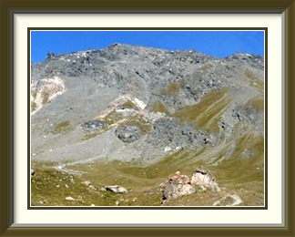
In cases like this, the term "day trip" stretches the meaning of the phrase. With my stuff prepared the night before, I was off by four thirty for the eighty or so kilometres to Kandersteg, where I caught the first car train through the Lötschberg Tunnel and was already heading down to the Rhône Valley at first light. The Turtmann Valley is protected from intensive tourist development, and the journey up its narrow roads was not a quick one; nevertheless I was parked at Vorderes Sänntum, where the public road ends, and ready to walk not long after seven a.m. The first part of the walk was along the slopes above the Turtmänna Stream as far as the reservoirs built to control the meltwaters of the Turtmann Glacier below the Tête de Milon, with the snows of the Bishorn in the background in this afternoon picture. The path then became more alpine on the way to the Turtmann Hut, perched on a buttress high above the reservoirs. Behind the hut, it continued into the Gässi, a notch in some low cliffs. The notch is secured by a cable for the upper part of its length, and the only part of the walk possibly justifying a low T4 rating. This opened out to the last green slopes of the day, which the track left in a curiously abrupt transition from old sun-warmed boulders and grass to the mound of gravel and stones bulldozed in relatively recent times by the Brunegg Glacier.
While enjoying the morning view across the tongue of the Turtmann Glacier to Les Diablons, I began to notice that the cairn fairy had put a lot of work into this area. Cairns popped up here and there along the moraine, some of them with individual styles reminiscent of those near the Lämmeren Hut. As for this one... did it require a building permit?
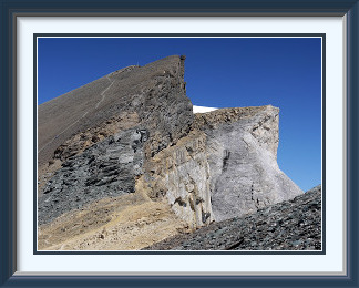
The rubble of the moraine gave way to exposed, furrowed rock further up, demanding care in where one placed one's feet, before more steep rubble below a band of cliffs led to the saddle called the Schöllijoch (3343 M.). This was a good place to rest after the long slog from the hut before skirting the Inner Barrhorn on yet more rubble to stand at the foot of the final ascent to the summit. It is here that the dual nature of the peak becomes evident, the rounded shaly slopes on the western side suddenly giving way at their highest points to vertical, even overhanging, cliffs looming over the Stelli Glacier to the east.
Standing at last by the weatherproof summit cross, you are at the highest point reachable by a conventional path in Switzerland, at least of this level of difficulty; anything higher usually involves crossing a glacier if nothing else. As if to illustrate the point, just beyond the Inner Barrhorn (with a lone hiker arriving on top) lies the Brunegghorn, barely two hundred meters taller and fairly clearly not a hill for walkers. Not much further away, behind a shoulder of the Bishorn, the summit ridge of the Weisshorn, the second tallest peak entirely in Switzerland, reaches for the sky. I had assessed the weather correctly, and it was cool but not cold as I munched my sandwiches. There was almost too much to look at, the Topali Hut a kilometre below on the other side, the whole of the Bernese Oberland along the northern horizon and, beyond the Turtmann Glacier, the Grand Combin and Mont Blanc far to the southwest.

The Trogenhorn is a limestone mountain at the head of the Eriz Valley in the Prealps north of Lake Thun in the canton of Bern. The summit is a pile of giant boulders which require care when crossing.
 The first week of September had been very warm, with temperatures
touching 30°C in some places, but now a low was moving down from
Scandinavia; the second week was shaping up to be a complete washout.
With the arrival of the first cold front only hours away, I made a
last-minute decision to squeeze one more walk in before the
enforced break. As it was already after breakfast, it was going to
have to be an easily accessible peak of modest height. But what
such peak was left that I had not already done many times? Well, in
the Prealps north of Lakes Thun and Brienz, there were a couple. The
Trogenhorn at the end
of the Eriz Valley near Thun was one. I threw a few essentials into
my rucksack and was off.
The first week of September had been very warm, with temperatures
touching 30°C in some places, but now a low was moving down from
Scandinavia; the second week was shaping up to be a complete washout.
With the arrival of the first cold front only hours away, I made a
last-minute decision to squeeze one more walk in before the
enforced break. As it was already after breakfast, it was going to
have to be an easily accessible peak of modest height. But what
such peak was left that I had not already done many times? Well, in
the Prealps north of Lakes Thun and Brienz, there were a couple. The
Trogenhorn at the end
of the Eriz Valley near Thun was one. I threw a few essentials into
my rucksack and was off.
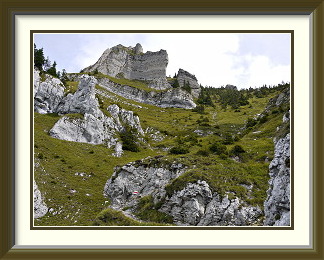
From the car park at Innereriz, the path ascended through a wood and then the usual alpine meadows. After the last farm chalet, it quickly became more businesslike, hairpinning up first through pine forest, then more aggressively up a grassy gully between the precipices bounding the peak on its northern side. With what looked like brand-new markings along its entire length, no time was wasted checking the route and progress was rapid.
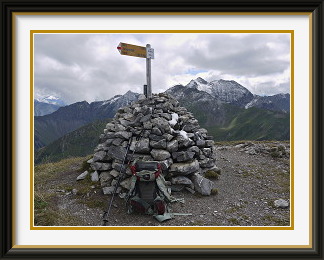
Less than two hours after setting off, I was on the summit and looking down on Innereriz and the road up the Eriz Valley, with my car park just left of the hamlet in the picture. The area around had been reduced by erosion to a pile of giant boulders, now beautifully adorned with lichen. Looking down at my feet, I suddenly noticed that I was wearing colour-coordinated footwear!
As I had hurried up the mountain, the weather had held off; on the summit, neighbouring peaks like the Hohgant and the Niederhorn were at first clear, but within minutes began to disappear behind rising cloud. While I was having my lunch on the topmost stone, merely one of the biggest boulders in the pile, the Trogenhorn stayed clear. Rising at last to begin the descent, I noticed that much of my perch was floating over the void.
Half an hour into the descent, the summit of the Trogenhorn had disappeared into the gathering overcast.
The Wiriehorn is a mountain in the Diemtigtal Valley in the Bernese Prealps. Access is from various points on the road up the Diemtigtal. There are well-formed tracks up the mountain's smooth western slopes, but the area is much better known for winter sport activities.
 September was shaping up to be a real disappointment. A week after
the last walk, the warm weather had not returned; in fact, the
changeable conditions were forecast to continue and get even colder
into the next week. With heavy rain threatening, I did the same as
last time: decided to jump only after breakfast and left in a hurry
for the straightforward Wiriehorn.
September was shaping up to be a real disappointment. A week after
the last walk, the warm weather had not returned; in fact, the
changeable conditions were forecast to continue and get even colder
into the next week. With heavy rain threatening, I did the same as
last time: decided to jump only after breakfast and left in a hurry
for the straightforward Wiriehorn.
In the Diemtigtal there was abundant parking at the foot of the Riedli ski lifts, which are closed in summer. The early part of the journey included a comfortable footpath past the hamlet of Allmiried, before more conventional conditions resumed as the Wiriehorn's northern cliffs came into view, unfortunately under a fairly dull sky. A stretch up a road was followed by the ascent of an alpine pasture and another stretch along a jeep track towards the last alpine chalet at Wirie. On the map, the contours of the Wiriehorn's northwest face are neatly spaced apart and roughly parallel. Sure enough, above that last chalet, the path ran for some distance across a smooth grassy slope before turning up the last ridge to the summit.
The cloud ceiling stayed fortunately well clear of the local peaks, allowing for some reasonable views. The Rothorn and the Spillgerten could be seen over the jagged shoulder of the nearby Tierlaufhorn. The summit cairn had a little patch of recent snow on it, not enough even to cool my drink. Rather improbably, it was the single, solitary speck of snow on the whole mountain, as a scan down the southeastern cliffs soon confirmed. Its nearest neighbour must have been somewhere on the satellites of the substantially taller Männliflue in the background.
I decided to make a circuit of the mountain going down, to avoid the jeep tracks and roads. Leaving the old path above Wirie and crossing the saddle between it and the Tierlaufhorn, a path led down the valley under the southeast face of the Wiriehorn, avoiding motorable tracks except at the location in the picture. Fortunately the weather remained dry for the rest of the walk back to the car.
The Brienzer Rothorn is a mountain on the border of cantons Bern and Lucerne just to the north of Lake Brienz. It has a cog railway to the summit from the lakeside, and is correspondingly crowded on fine days. There are great views of the lake and the Bernese Oberland peaks.
 It was the last Sunday of the year's stay in Switzerland; the weather had
finally relented the previous Thursday and stable autumn conditions prevailed
over the country. Going really high in the Bernese Alps was probably not on the
cards any more, however, as the previous walk had revealed fresh snow only just above
that modest summit. To get a decent amount of ascent, it would be necessary to
start low. The Congenial Swiss Lady was interested in doing something that day also,
but would not want a really long ascent. One peak satisfying these conflicting
conditions was the Rothorn above the lakeside village of Brienz; rising
nearly 1800 metres above the lake, it not only had a path starting in Brienz,
but a cog railway starting there too, and having an intermediate stop about
halfway up.
It was the last Sunday of the year's stay in Switzerland; the weather had
finally relented the previous Thursday and stable autumn conditions prevailed
over the country. Going really high in the Bernese Alps was probably not on the
cards any more, however, as the previous walk had revealed fresh snow only just above
that modest summit. To get a decent amount of ascent, it would be necessary to
start low. The Congenial Swiss Lady was interested in doing something that day also,
but would not want a really long ascent. One peak satisfying these conflicting
conditions was the Rothorn above the lakeside village of Brienz; rising
nearly 1800 metres above the lake, it not only had a path starting in Brienz,
but a cog railway starting there too, and having an intermediate stop about
halfway up.
After a slightly early start to pick her up and drive the ninety or so kilometres to Brienz, I dropped the CSL off at the lakeside terminus of the Brienzer Rothornbahn to catch a train just after eight, then quickly found a parking place a little up the hill at the back of the village. The first part of the walk headed uphill beside the Trachtbach stream, with its nets to catch flood-borne rubble. The ring structure of these nets is designed to stretch enormously and absorb the energy of the debris rather than break all at once. The nets are there for a reason - in 2005 days of heavy rain provoked an avalanche into the upper reaches of the stream, and tens of thousands of tons of rubble roared through the village and into the lake, taking some twenty houses with them. It wasn't just Brienz which was affected, however. Conditions were terrible everywhere, and the Aare, into which much of the Bernese Oberland drains, rose to the point where the Old Town of Berne suffered severe damage.
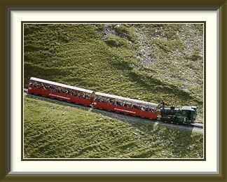
I hurried up to the halfway station at Planalp so that the CSL wouldn't have to wait long, and we set off along the track for the summit. This is not the most exciting of walks, traversing as it does the virtually treeless, grassy valley bowl between the Rothorn and the Dirrengrind crags. The chief point of interest on the way is the little steam-powered train heading up below the Dirrengrind before it crosses the Rothorn's monotonous slopes. The railway seems to operate in a fairly old-fashioned way; at the passing place called Oberstafel, the driver got out to operate the points by hand.
There is a certain amount of hullabaloo around the summit, as it is also the terminus of a cable car from Sörenberg to the north. The highest point is sufficiently far from both termini that much of the crowd never gets there, but it is not a place to visit if you want to be alone. It has a good view over the tourist facilities to its sister peak, the Schongütsch, also sprinkled with tourists, but where it comes into its own is as a viewpoint over Lake Brienz and the high peaks of the Bernese Oberland. In this picture, the view extends from the Eiger on the left to the Diablerets on the extreme right. More than a mile below, the passenger boats plying the lake resemble insects on the surface of a pond.
The Sasseneire is a mountain on the ridge separating the Val de Moiry and the Val d'Hérens in the Pennine Alps in the canton of Valais. Access is from the hamlet of Villa above Evolène or (much shorter) from the Lac de Moiry dam to the east. There are excellent views of the Dent BLanche and as far as Mont Blanc.
 The end of the year's stay in Switzerland was two days away; I had done four walks
in the month, but the dip in the weather had meant that two were on quite
modest peaks and the last, though longer, had been along something of a tourist
highway. Slim pickings overall... was there time left for a more challenging walk,
now that a durable high pressure zone was in place? The snow that had fallen to
low levels in the Bernese Alps would still not be entirely melted and going
high there was probably not on. I had no idea what conditions were like in the
Valais; a search for webcams in the area merely revealed how poor most of them
were. I would just have to try it.
The end of the year's stay in Switzerland was two days away; I had done four walks
in the month, but the dip in the weather had meant that two were on quite
modest peaks and the last, though longer, had been along something of a tourist
highway. Slim pickings overall... was there time left for a more challenging walk,
now that a durable high pressure zone was in place? The snow that had fallen to
low levels in the Bernese Alps would still not be entirely melted and going
high there was probably not on. I had no idea what conditions were like in the
Valais; a search for webcams in the area merely revealed how poor most of them
were. I would just have to try it.
For the second time in the month, I caught the first Lötschberg train and drove from Goppenstein down to the Rhône Valley, in pitch darkness as the days were shorter now. This time I drove westwards, looking up at the peaks lining the valley in the dawn light, trying to assess the snow conditions. All of them had fresh snow near their summits, so I forgot about them and stuck to my original idea of picking a mountain with a physical orientation like that of the Barrhorn to maximise the chances of a snow-free walk.. There was one in the Val d'Hérens, so I turned off the motorway at Sion and headed up that valley, past Les Haudères to the end of the road at the hamlet of Villa. Above Villa lies the Sasseneire, accessible via a path and a pass, all on its southwest side, just what I was looking for.
Lying at 1740 metres, the hamlet hadn't got much woodland above it and the path was soon rising steadily through alpine pastures. Here were the first good views of the Sasseneire's long crest. The cairn fairy seemed not to have done much work locally apart from this fine specimen beside a small tarn at a place called Béplan. The grass only began to peter out just below the Col de Torrent, already above 2900 metres. From the pass, the summit was not visible, but there was a faint impression in the scree (roughly above the cross) showing the way. This soon led onto the summit ridge, and the rest of the way was between the dry southwestern and the increasingly snowy northeastern slopes. At last the inevitable cross came into view, and the final ascent was somethat steeper than it had looked from the valley.
The cross was of a less durable kind than that on the Barrhorn, and a search around its foot showed no evidence of a summit book, unusual for a peak of this height. Conditions on the mountain were as good as I could have hoped for; the slopes I had ascended stretched snowless down to Villa on its sun terrace 350 metres above the Val d'Hérens, but on the other side winter was near and some of the tarns were already frozen.
As a viewpoint, the Sasseneire was even better than the Barrhorn. Behind the Lac de Moiry, its waters coloured by glacial deposits, lie the Weisshorn and the Zinalrothorn, the former looking much more sombre here than it did from the Barrhorn. Beyond the ridge just ascended, the view encompasses the Moiry Glacier and the Dent Blanche, another one of Switzerland's giants. The Sasseneire is also a much better viewpoint for Mont Blanc and its neighbours in France.
Thanks to the early departure, I was able to spend nearly two hours of sunshine and shirtsleeve weather drinking in the view before the time came to set off back along the ridge and down the slopes past that cairn at Béplan, its coating of colourful lichen glowing in the afternoon sun. As I descended past the first chalets above Villa, the distant Ferpècle Glacier was framed by the Dent Blanche and the Grande Dent de Veisivi, one more memory to take back to New Zealand in two days' time.