


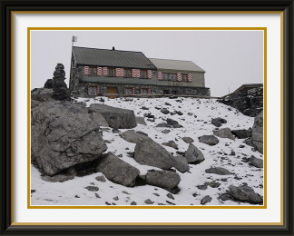
The Fründen Hut belongs to the Altels Section of the Swiss Alpine Club. It lies on a terrace at the tongue of the receding Fründen Glacier. It has a grandstand view of the Blümlisalphorn and Doldenhorn peaks as well as of the Oeschinen Lake far below.
 2021: Access to this track is barred. See below.
Summer had ended without improvement, and the generally cloudy and cool weather continued into the start of September. However, the television weather forecast showed a largely cloud-free map of Switzerland for the day, with only some cumulus in the mountains. That was good enough to do something, especially as the Congenial Swiss Lady was free again and wanted to get out too.
A recent cold front had briefly brought snow down to about 2000 metres in many areas, so it was pointless to try anything really high. There were several huts that would do; the Fründen Hut was one I hadn't been to in more than ten years and the CSL had never seen it. Perched on a rock outcrop a kilometre above the Oeschinensee, it has a grandstand view of the Blümlisalp and Doldenhorn peaks. Any fresh snow should be disappearing fast at that level, so it would almost certainly be reachable.
We parked the car just outside Kandersteg and headed up a mixture of jeep tracks and paths to the Oeschinensee's lakeside restaurant. The unseasonable snow on the Oeschinengrat above was an indication of what we might expect nearer the hut. The track followed the lakeshore anticlockwise for a time, then headed up the forested slopes to the south. Above the trees, it crossed an area of bare rock where streams descending the cliffs above had eroded deep channels. Two of these had had new bridges installed. Ten years earlier, it had been necessary to cross them directly a little higher up, right where they emerged from the cliffs. Now that small challenge was gone, part of a trend towards putting safety before interest in the Alps. This is not only the case with tracks; gleaming new tunnels have made some pass roads less exciting than they used to be. In fairness, this track is the only one to the hut, so that not all its traffic is recreational.
At the foot of the vertical rock wall below the hut, cloud was beginning to surround us as we passed giant boulders from an ancient landslide, one of which had split neatly along its plane of stratification. Soon we were traversing wet snow in the gloom, and at the level of the Fründen Hut itself, the snow was more or less continuous. Nothing of the view was visible, but on the tongue of the Fründen Glacier behind the hut, we could see lessons in glacier travel going on. I found a bench free of snow and had my sandwiches in the mist, after which we had a hot drink in the hut, which was still open for the summer season.
On the way down, it wasn't long before we were below the fog and the snow once more. From the middle reaches of the track, there is a view across the Fründenschnur, a string of barely-connected bits of green in the middle of the vertical cliffs at the back of the lake. Against all appearances, a path runs across this to the alp in the distance, but it's not one for the faint-hearted. No doubt the lone ibex we passed at this point would have felt at home on it.
FRÜNDEN HUT TRACK CLOSURE
The approach described above to the Fründen Hut has been closed since late 2019 by the authorities in Kandersteg on account of the danger of rockfall from the Spitzstein (q. v.). This leaves the Fründenschnur track (mentioned above) across vertical cliffs as the only way for non-mountaineers to reach the hut. Previously rated as a T5 walk, the steel cable across the cliff parts has been beefed up, and the rating is now T4 according to the hut warden, but it is not a walk to be taken lightly. Something of the exposure on this track can be gleaned from the hut's recommendation that walkers use a basic via ferrata kit (simple climbing harness, carabiner clip-ons and helmet) to stay attached to the cable at all times. If you are absolutely sure of your head for heights, you may not need this, but the cliffs are no place to start having doubts.
The hut's own site (German only in 2021) will have the latest information.

The Cheval Blanc is a mountain in the Chablais Alps on the French-Swiss border. Access is from the Lac d'Emosson dam parking, itself reached by turning off the road to Chamonix just before the French border. The track passes a site of primitive dinosaur footprints in rock some 240 million years old. There are good views of the reservoirs and of Mont Blanc from the summit.
 Now that summer was officially over, the weather had been bringing some
relatively sunny days in the early part of September. After a few of
these during which I had other appointments, the weather was reverting to
character when I finally had a free day. However, the western end of the
Valais was looking a little less threatening; it was supposed to be near
cloudless in the morning, with a risk of thunderstorms by afternoon.
Unusually, both the Walking Friend and the CSL were available to join in. It was a
matter of three hours to pick them both up, continue on the motorway to
Martigny and then cross the Col de la Forclaz almost to the French border,
before turning up the narrow road to Emosson and the Dam of the same name
where the road ended.
Now that summer was officially over, the weather had been bringing some
relatively sunny days in the early part of September. After a few of
these during which I had other appointments, the weather was reverting to
character when I finally had a free day. However, the western end of the
Valais was looking a little less threatening; it was supposed to be near
cloudless in the morning, with a risk of thunderstorms by afternoon.
Unusually, both the Walking Friend and the CSL were available to join in. It was a
matter of three hours to pick them both up, continue on the motorway to
Martigny and then cross the Col de la Forclaz almost to the French border,
before turning up the narrow road to Emosson and the Dam of the same name
where the road ended.
As we put our boots on in the car park, the Emosson Dam and the Aiguilles du Van were still catching the morning sun, and we could expect fine weather for at least the early part of the walk. The border with France runs across the tops of the Aiguilles, but descends to the stream out of sight below the dam, so that the entire structure lies in Swiss territory. The path began by following the service road across the dam, but was soon forced by fences onto the slopes above it; indeed it quickly became clear that the power company had invested considerable resources in keeping walkers off their road. The track turned slowly away from the reservoir and headed into the narrow Gorge de la Veudale between the peaks along the border and smaller hills to the north. The lower part of the gorge had lovely early autumn colours before it became stonier and steeper further up. At its crest, there was a view of our track traversing the barren slopes of the Pointe à Corbeaux, after which we could see our destination ahead.
From the summit, the view included not only our starting point, but the Old Emosson Reservoir, empty while its dam was being raised by twenty metres as part of a project to generate and store power by the flow of water either way between it and the main reservoir, roughly three hundred metres lower down. Directly to the south, Mont Blanc itself was hidden, but the eastern end of the Mont Blanc chain could be seen above some nearer hills, with the Argentière Glacier flowing past the Aiguille du Chardonnet from the French-Italian border peaks in the background. The cairn fairy had put in some sterling work here too, with this substantial effort just down the slope on the French side as well as the usual one on the summit.
While there was a fair amount of haze and cumulus, it did not come to thunderstorms and we were able to take our time around the summit, even making an excursion along a ridge to a subsidiary peak inside France. During the descent, cloud stayed off the Perron Peaks along the French border, and the afternoon warmed our backs as we picked our way through the boulders in the Gorge de la Veudale on the way back to the dam and our car.
The Augstbordhorn is a mountain in the Pennine Alps in the canton of Valais. It lies at the northern end of the ridge of higher peaks stretching north from the Weisshorn and the other giants west of Zermatt. Along a high ridge to the west of the Augstbordhorn lies the slightly higher Dreizehntenhorn with views overlooking the Turtmann Valley.
 A day of thundery showers after the last walk had given way to weak sun
and murky haze. Now a day of cold rain was forecast for areas north of
the Alps. Once again the Valais came up trumps, with "sunnier" conditions
expected to last past the middle of the day. Of course, "sunnier" than
rain clouds didn't necessarily mean "sunny", but it was worth a try. My SAC
guide1
listed several peaks not far from the Lötschberg Tunnel; those on
the southern side of the Rhône Valley would be further from the
cold air to the north and present the lowest risk. At 2973 metres, the
Augstbordhorn seemed as good a choice as any; the straightforward ascent
of less than a thousand metres could be easily abandoned if the weather
turned against us.
A day of thundery showers after the last walk had given way to weak sun
and murky haze. Now a day of cold rain was forecast for areas north of
the Alps. Once again the Valais came up trumps, with "sunnier" conditions
expected to last past the middle of the day. Of course, "sunnier" than
rain clouds didn't necessarily mean "sunny", but it was worth a try. My SAC
guide1
listed several peaks not far from the Lötschberg Tunnel; those on
the southern side of the Rhône Valley would be further from the
cold air to the north and present the lowest risk. At 2973 metres, the
Augstbordhorn seemed as good a choice as any; the straightforward ascent
of less than a thousand metres could be easily abandoned if the weather
turned against us.
The CSL was once again free, and we took the tunnel, crossed the Rhône Valley and drove up the narrow road through hillside villages like Eischoll and Bürchen to the winter sports location of Moosalp, where the big car park was almost empty in the off-season. As we headed up through the last of the pines, fog on the slopes hid the view, but higher up conditions began to improve and the Bietschhorn poked its head out of the clouds. Soon we were walking in sunshine and I saw once again that some people on the mountain weren't planning to walk all the way down. Near the minor viewpoint called the March, we crossed surprisingly gentle terrain for the altitude of about 2800 metres, and then it was a matter of a half an hour or so to the Augstbordhorn's somewhat understated summit.
The sun was still shining, and it was barely midday. We would be down very early at this rate. However, there was another possibility... three kilometres away as the crow flies was the Augstbordhorn's twin at the head of the upper Ginals Valley, the 3052-metre Dreizehntenhorn. I could see the whole of the Augstbord ridge joining the two peaks; it never dipped below 2800 metres and looked for the most part very modestly jagged. That would be a way to make a full day out of it.
So it was that I left the CSL to make her way at leisure back to Moosalp and began the trip along the ridge. For much of its four Km. or so, it was remarkably benign for the altitude. Only one stretch of eroded, reddish rock offered any challenge, and in less than two hours I was standing at the Dreizehntenhorn's summit rocks. There was time for a quick snack while enjoying the view across the valley to the now distant Augstbordhorn, but the sky had clouded over and it wasn't much above freezing, so I didn't stay long. A good decision; by the time I was back on the first summit, the Dreizehntenhorn was enveloped in gloom.
Of the four 3000-metre massifs in the Western Bernese Alps, the Wildstrubel, the Wildhorn, Les Diablerets and the Grand Muveran, the Wildstrubel is perhaps the most impressive. Its long, almost level summit ridge dominates the view from Lenk and Adelboden. While most sides are protected by glaciers, there exists one long path up the western slopes to the highest point which avoids the ice.
 Although there had not been a single stable zone of high pressure over
Switzerland since I arrived in July, the weather was still better than it
had been so far, and the forecast offered for the first time
the sheer luxury of several
consecutive days good enough for walking. I chose the most
promising one and made a plan. For the last walk of the season, I would
try to go high, and start from a reasonably low starting point as well
for the exercise.
Although there had not been a single stable zone of high pressure over
Switzerland since I arrived in July, the weather was still better than it
had been so far, and the forecast offered for the first time
the sheer luxury of several
consecutive days good enough for walking. I chose the most
promising one and made a plan. For the last walk of the season, I would
try to go high, and start from a reasonably low starting point as well
for the exercise.
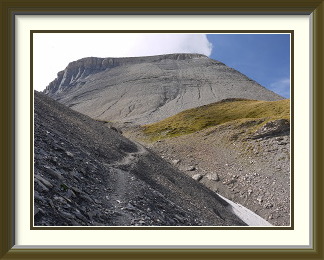
The Wildstrubel2 fit the bill perfectly; from the end of the public road at the Simmen Waterfalls behind Lenk, the ascent was even bigger than that from Stechelberg to the Schilthorn. (Note that the walk described here has no connection with that to the Wildstrubel Hut, which starts from a different valley and offers no ice-free access to the summit.) I hadn't failed to notice the mention in the weather forecast that, though the day would be fine and sunny, the air flowing up from Portugal was "not completely dry". Cloud would rise by the middle of the day, and showers might occur in the mountains. It would be doubly important to start early.
The long drive down the narrow Simmental highway was duly complete by dawn, and I was on the path just before sunrise. The first stretch was a motorable track up to the little Rezliberg alp. Here the path turns towards the Flueschafberg cliffs and the going gets more interesting. The whole area faces northwards and is consequently wetter than average, so that care is needed as the path snakes up the sunless cliffs, negotiating a few secured sections on the way. This part of the walk ends at a very picturesque tarn called the Flueseeli, its colours soft in the morning light before the sun reached it. A good spot for a morning snack!
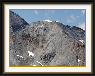
Skirting the lake to the south, the track offers a view of Lenk and the Upper Simmental as it climbs above the last of the grass. The marked and signposted path continues on towards the Tierberg Saddle; the fork for the Wildstrubel, by contrast, has hardly any markings except the name of the peak written on a rock at the point where it starts. The reward for the long stretch of rubble that follows is the ever-improving view. The first tongues of ice appear below the Gletscherhorn opposite, before the view encompasses the whole western end of the Plaine Morte Glacier. Higher up, the rubble grows steeper and there are precipitous views down to the tiny Rezli Glacier Lake. At last, the track reaches the southern shoulder of the mountain, and only a couple of hundred metres of ascent over easier ground remain.
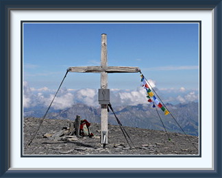
The whaleback summit is remarkably gentle for the altitude, essentially level around the highest point, where the well-secured cross stands. Indeed, it is so level that there is nothing to sit on, so that previous walkers had been forced to gather a pile of flat stones for the purpose. I had to walk some distance to the north to see down to the Upper Simmental, now more than two kilometres below. On the other side, I could see the track and the Plaine Morte Glacier, now dappled by cloud. Just a kilometre away was the Mittelgipfel, to within ten centimetres the same height as the summit I was standing on, and some two kilometres further away was the Grossstrubel, one whole metre lower and the eastern extremity of the massif. Though the forecast clouds were rising, they never threatened, and I enjoyed a comfortable hour on top.
On the way down, I came upon the little Flueseeli at its most serene. With the only significant stream feeding it entering the lake below the surface, there is nothing to stop it mirroring the sky on a calm day. A fitting memory to take away from the last walk of a season where I had achieved everything I wanted to despite the unsettled weather.
SOME REMARKS ABOUT THE TRACK UP THE WILDSTRUBEL
The difficulty rating given to a walk is always to some extent a matter of opinion, but the divergence of the ratings I have seen for this walk reaches extreme levels. My SAC guide3 rates it as T5, which is absurd, at least in summer conditions. Some Internet commentary rates the part above the Flueseeli as T2, also not reasonable. While one might argue whether the cliffs below the lake or the few rocks steps on the upper path merit a rating within the T4 range in late summer, the remoteness of the terrain, the weak to nonexistent markings and the mostly inconspicuous (in 2014, at least!) cairns on featureless rubble slopes require good orientation skills, a requirement of the T4 rating specification. In early summer, big snow patches would add to the difficulty.
The track from the fork mentioned above is absent from my 1967 edition of the 1:50,000 LK, but has appeared by the 2004 edition of the same map. If enough walkers tread it out every year, it may become easy enough to follow that the rating does drop, and it might eventually be marked in red on the walking maps!