


The Männliflue is a mountain in the Bernese Alps. It is the highest peak in the Diemtigtal area and lies just off the main Niesen Chain, being only six hundred metres from its nearest point at the Winterhorn. It is higher than all but the two southernmost peaks in the chain itself. Access is from the Otteren Pass, easily reachable from the Diemtigen or the Engstligen Valleys.
 We had begun our stay relatively late in the year; it had been hot earlier in
August, but we arrived to dull, coldish weather. This threatened to make
a washout of the rest of August, but fortunately passed off within
a few days, by which time the CSL happened to be free to come along. Given
the lateness in the season, I didn't want to start with something too low, so
I headed for the Diemtigtal, picking her up en route. We would try the highest peak
in this valley, and the third highest peak in the whole Niesen chain, the
Männliflue. Unlike all other significant tops in this long chain, it
lies more than half a kilometre to the west of the watershed, so would offer
no views of the Engstligen Valley to the east, but that would still leave
plenty to see.
We had begun our stay relatively late in the year; it had been hot earlier in
August, but we arrived to dull, coldish weather. This threatened to make
a washout of the rest of August, but fortunately passed off within
a few days, by which time the CSL happened to be free to come along. Given
the lateness in the season, I didn't want to start with something too low, so
I headed for the Diemtigtal, picking her up en route. We would try the highest peak
in this valley, and the third highest peak in the whole Niesen chain, the
Männliflue. Unlike all other significant tops in this long chain, it
lies more than half a kilometre to the west of the watershed, so would offer
no views of the Engstligen Valley to the east, but that would still leave
plenty to see.
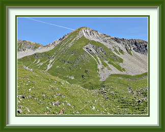
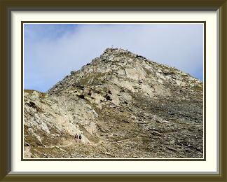
We parked when the road became payable, conveniently leaving just the right amount of work for the feet at that point. The first stage of the walk was a relatively unexciting trudge up wooded slopes. By the time we reached the Oberberg Alp, there was a pleasant view of the upper reaches of the Diemtigtal in the late morning sun. Even the sea of dung around the farm buildings didn't spoil the enjoyment. Another conventional slog up grassy slopes took us to the junction with a track heading over the nearby Otterenpass and down into the Engstligen Valley. Just beyond this, we came upon a small tarn with a fine view of the peak ahead. Our route lay up the steep grassy slope from the saddle to the left; all other faces of the mountain are stony. This tarn also offers a picturesque view of the southern end of the Niesen Chain. The peak in the distance beyond two lesser known summits is the Gsür.
That last slope was indeed steep, and we were glad of the rest when we reached the slabby rocks and grass at the Männliflue's summit. A couple of other walkers were soon gone, and we had time to enjoy the panorama of the Bernese Oberland in peace. Close by was the nearest point on the watershed, the Winterhorn. The traverse of the ridge to get to it didn't look impossible, but that was for another day; it was time to start the descent. On the way past the tarn, we spotted a boulder in an interesting state of erosion. Perhaps the channels began as glacial scratches? Soon afterwards, the cloud thickened and a light, fitful rain began to fall, but not enough to inconvenience us. By the time we reached the car conditions were dull.

The Mittaghorn is a peak near Saas-Fee in the Pennine Alps. It can be approached from Saas-Fee or the villages below it in the Saas Valley. Less fit walkers can shorten the journey by taking the Plattjen lift from Saas-Fee. The uppermost part of the path is quite steep. The summit can be surprisingly busy due to the popular via ferrata on its northwest ridge. There are magnificent views of the Mischabel Group and other 4000-metre summits around Saas-Fee.
 With the shortage of virgin summits anywhere near Bern and the ever longer journeys
needed to get to new places, a new tack was necessary. For many years of our life there,
the wife and I had camped around Switzerland and the neighbouring countries. It was the
work of an afternoon to dig out the old camping equipment from the basement and
visit a local camping business to bring old and perished items up to date. Then we were
off across the Lötschberg, down into the Rhône Valley and back up the other
side into the high Saas Valley; there were quite a few promising walks there. Our campsite
lay just above Saas Grund at 1580 metres, and light showers were fading away as we put our
tent up. There was some cloud on the high peaks, but the weather promised to be reasonable
for a few days.
With the shortage of virgin summits anywhere near Bern and the ever longer journeys
needed to get to new places, a new tack was necessary. For many years of our life there,
the wife and I had camped around Switzerland and the neighbouring countries. It was the
work of an afternoon to dig out the old camping equipment from the basement and
visit a local camping business to bring old and perished items up to date. Then we were
off across the Lötschberg, down into the Rhône Valley and back up the other
side into the high Saas Valley; there were quite a few promising walks there. Our campsite
lay just above Saas Grund at 1580 metres, and light showers were fading away as we put our
tent up. There was some cloud on the high peaks, but the weather promised to be reasonable
for a few days.
The first walking day dawned, and I enjoyed the unheard-of luxury of stepping out of our tent, donning my rucksack and setting off, for the track began at the campsite. The first part led up the Kapellenweg, a path for religious pilgrims from Saas Grund to Saas Fee, a couple of hundred metres higher. The way is lined with little shrines containing depictions of events in the life of Christ; they date from about 1710, but had recently been refreshed; this isn't the sort of thing I usually encounter in the Alps. The fifteen shrines along this conventional T2 path end with a wayside chapel whose altarpiece is more reminiscent of temples in Southern India than Switzerland's usual offerings.
As I skirted the urbanisation of Saas Fee, the sanctimeter readings sank at last to background levels, and the path began a conventional, moderately steep ascent towards Plattjen, the snow cannon on the way an indication that the place was probably busiest in winter. From the rocky promontory just above the cable car terminus, there was a good view of the Mittaghorn above.
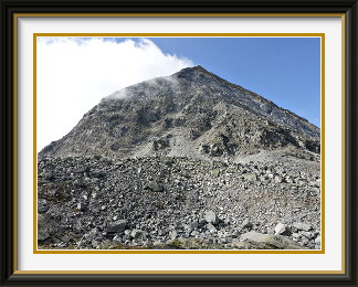
The next stretch of the path skirted the peak roughly at the 2600 metre contour, enlivened only by a rockslide of surprisingly big boulders just around a corner beyond Plattjen. Twenty minutes or so later, a blue signpost indicated the start of the track to the summit, where the easy path gave way to five hundred metres or so of relentlessly steep hairpins through patches of colourful rubble. Perhaps in tune with the religious sentiments expressed lower down, the summit cross was bigger than most, and carefully earthed against lightning strikes. Note the earthing strap snaking through the boulders right to the bottom of the photo!
The view from the summit is, not surprisingly, splendid. Among the many 4000 metre peaks nearby are the Dom, the highest peak entirely inside Switzerland, and the Alphubel with its rivers of ice filling the foreground. To the north, I could see over the Plattjen to Saas-Fee on its terrace and the Saas Valley below. Our campsite in Saas Grund is clearly visible, just to the right of and below the centre of the photo.
When I reached the summit, I was puzzled at first by the small crowd of walkers there; the path up hadn't been that busy! The solution soon became clear... there is a popular via ferrata up the other side of the mountain, and a steady stream of climbers, indeed most of the people on the mountain, were arriving by this route. Back down at the rockslide, they combined with more casual walkers to create almost a procession, and I had to wait quite a while before I could get this photo of the slide without anyone on it.
The Jazzihorn is a peak on the Swiss-Italian border lying to the east of the Mattmark Reservoir in the Pennine Alps. It can be approached from the dam via the Ofental and the saddle called the Jazzilücke. There are excellent views of the 4000-metre peaks around Saas-Fee both from the summit and from the path through the Ofental.
 We were lucky enough that the weather remained dry, if a little cool, for another
two days. The first we spent hanging around in Saas-Fee doing a little shopping,
after taking the Postauto up to the Mattmark Dam at the head of the valley earlier
to check conditions there.
A glance at the walking signposts and the surrounding peaks was enough to
convince me that the area was worth a visit.
The second day dawned cloudless and clear in Saas Grund. It was time for a walk.
We were lucky enough that the weather remained dry, if a little cool, for another
two days. The first we spent hanging around in Saas-Fee doing a little shopping,
after taking the Postauto up to the Mattmark Dam at the head of the valley earlier
to check conditions there.
A glance at the walking signposts and the surrounding peaks was enough to
convince me that the area was worth a visit.
The second day dawned cloudless and clear in Saas Grund. It was time for a walk.
There are various peaks of 3000 or so metres around the reservoir; such information as I could find indicated that the Jazzihorn was as good as any of them. Thus it was that I caught the first Postauto up to the dam at eight o'clock and set off along the crest. The path ran for a while just above the high water level, offering fine views across the water to one of Saas's 4000ers, the Strahlhorn. Then the track into the Ofental led steeply away from the reservoir and I spent a lovely hour or so ascending alpine grass and gravel in the morning sunshine, with no more than two or three other walkers visible the whole time. Beyond the fork where it diverged from the way to the Ofental Pass, the last stretch of the track to the saddle called the Jazzilücke became quite steep. Here, several bent steel marker poles gave mute evidence of the force exerted by heavy old winter snow when it starts to slip.
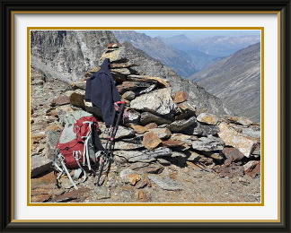
At the Jazzilücke, I had reached the border with Italy. Already above 3000 metres, it was a good place to take a short rest before skirting the Jazzihorn on the Italian side to reach a more propitious place to start for the summit. The track around the back of the mountain traverses some interestingly steep cliffs before coming out onto gentler terrain. It leads further to the Antronapass at the head of the Furgg Valley, and offers a way to walk all the way back to Saas Almagell, but a stony terrace with a view of the Weissmies was the best spot to turn towards the summit. The rest of the ascent was a trackless slog up steep boulders, slithery at times where they were sitting on a layer of half-frozen silt, and ending with a short walk along the nearly horizontal summit ridge to the summit cairn.
On top at last, it was clear that the international border was a weather border also. A layer of cumulus hid the Italian valleys; the few gaps revealed only an intense haze below. Lots of unknown (to me) peaks in the Valle Anzasca area jutted out of the clouds. By contrast, the view northwards to the Stellihorn remained perfectly clear all day. I munched my sandwiches in solitary splendour until I was surprised by a lone Swiss climber suddenly appearing at the summit by a more direct route.
Then it was time to retrace my steps to the steep cliffs and the Jazzilücke before the long walk down the Ofental in the afternoon sunshine. Back at the campsite before even six o'clock, I reflected on the difference from the days when I had to drive to and from Burgdorf.
The Lower Tatelishorn is a modest peak on a shoulder of the mountain called the Altels, situated at the northern end of the latter's great triangular northwest face. It has good views over the Gemmi Pass approach and, more steeply, down into the Gasterntal. Some five hundred metres higher, its bigger brother, the Upper Tatelishorn, can be reached over scraps of track when time allows.
 The weather continued fine and warm after we returned from Saas Grund until it
was again time for a walk. After the last two relatively distant peaks, I
cast around for something more easily reached. Kandersteg was an obvious place
to look, but was there anything left to do there? In the event, there was one
peak that offered a straightforward ascent, the Tatelishorn. It came in Unter
and Ober versions, so to speak, but even the former promised good views over
the Gasterntal and the approaches to the Gemmi Pass. The latter was five hundred
metres higher, and I had to do some shopping before I set out, so I would settle
for the lower of the two.
The weather continued fine and warm after we returned from Saas Grund until it
was again time for a walk. After the last two relatively distant peaks, I
cast around for something more easily reached. Kandersteg was an obvious place
to look, but was there anything left to do there? In the event, there was one
peak that offered a straightforward ascent, the Tatelishorn. It came in Unter
and Ober versions, so to speak, but even the former promised good views over
the Gasterntal and the approaches to the Gemmi Pass. The latter was five hundred
metres higher, and I had to do some shopping before I set out, so I would settle
for the lower of the two.
From the car parking area of the Sünnbuel cable car at the back of the Kander Valley, a businesslike track led steeply up through the pine forests to the upper station of the old Stock cable car, replaced in 1991 by the Sünnbuel one and now partially demolished. The cars of the old Stock could only take about eight people at a time. I remember turning up once and, seeing no queue, going to buy a ticket; it turned out that there was no queue because they were selling tickets for the tenth or twelfth next run. Walking was much quicker.
A jeep track (perhaps once used to service the Stock equipment) led around the corner and through cliff edge forest high above the Gasterntal, coming finally out into the pleasant high valley called the Spittelmatte, where the little wooden bridge in the photo leads to the left off the main track towards the Gemmi. It was necessary to wade through a surprising number of braids of the Schwarz Bach before the track began its ascent into yet more forest, so this is probably not a walk to be undertaken after wet weather. Some time after the last of the trees had been left behind, the rest of the way across grass and scree to the Unteres Tatelishorn became obvious. What also became obvious as I approached the summit was that I would not be alone on top.
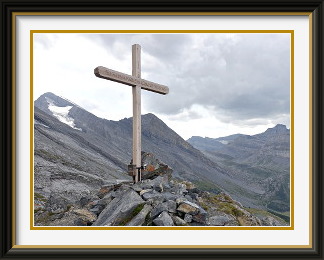
There is a big summit cross, of course, but this one has a surprisingly profane inscription1, perhaps because it dates only from 2016! There is a fine view over the much more precipitous northern side of the mountain to the Doldenhorn and the Gastern Valley beyond. As I ate my sandwiches on top, the skies were darkening from the west. It was time to start down; the Ober peak would definitely not have been a wise choice. Halfway down to the Spittelmatte, distant thunder sounded and showery rain began, enough that I had for once to put on my rainproof jacket. A single bolt of lightning crashed into the slopes a couple of hundred metres above and then the rain was gone as quickly as it had arrived.
Back at the car park, I crossed the road to enjoy one of Kandersteg's secret advantages for walkers... the Kander. This stream carries high volumes of water from the huge Kanderfirn glacier in summer, and it flows fast enough that it is still icy when it reaches the village. The sensation of plunging hot, tired feet into its rushing waters is one of life's pleasures. For about thirty seconds anyway... then the pain begins...
The Sparrhorn is a mountain on the south side of the Bernese Oberland. It can be reached from various minor roadheads above the resort of Blatten. The ascent up its mild southern slopes brings the walker to a panorama of rock and ice to its north, where the Upper Aletsch and Beich Glaciers flow down from the Aletschhorn (4195 M.) and the Nesthorn (3820 M.) respectively.
 It was still warm, but the weather was about to make a big turn for the worse
according to the forecasters, so I decided to grab one more walk before things
went to pieces. In case the rain arrived first on the northern Alps, I would
go yet again across the Lötschberg to the safer climes of the Valais. The
Sparrhorn offered plenty of height, but an absolutely straightforward path in
dubious weather; it also lay well away from anywhere I had ever walked, so
promised new views.
It was still warm, but the weather was about to make a big turn for the worse
according to the forecasters, so I decided to grab one more walk before things
went to pieces. In case the rain arrived first on the northern Alps, I would
go yet again across the Lötschberg to the safer climes of the Valais. The
Sparrhorn offered plenty of height, but an absolutely straightforward path in
dubious weather; it also lay well away from anywhere I had ever walked, so
promised new views.
After descending into the Rhône Valley as far as Brig, it was necessary to drive back up the hill to Blatten. Narrow roads lead further up the slopes before petering out; the one to Egga looked as good as any, and indeed it ended at a pretty hamlet with plenty of free parking and a signpost for the Sparrhorn.
A friendly local offered advice about the best of the various paths to take, and I was quickly on my way up through forest to the well-known Hotel Belalp above the tree line. Shortly afterwards came the Tyndall Monument commemorating the prominent 19th century Anglo-Irish physicist and mountaineer of that name who made his summer home nearby. The track continued up through the last of the grass past the top of the Hohbiel chairlift before it passed a hefty cairn with a bench seat beside it. The cairn fairy must have needed a rest! Shortly afterwards the track crossed some rockslides, and here it became clear that quite a lot of effort had been put into making this summit accessible, for suitable stones had been laid flat to provide a sort of paving across the slides.
Around a steep corner, the last stretch to the summit came into view, and it was clear that I would have company there. At the top, a whole new panorama opened up towards the high peaks of the Bernese Oberland. The Schinhorn towered over the confluence of the Beich and Oberaletsch Glaciers. There was, of course, the regulation summit cross and a view along a ridge to nearby summits reachable by more demanding scrambling if there had been time. Directly below, the tongue of the Oberaletsch Glacier was barely visible under its load of ground-up mountain. Note the track to the Oberaletsch Hut threading its way across the slopes high above the glacier. These slopes belong to the Fusshörner, some of the least walkable looking hills in the neighbourhood.
The weather remained locally friendly during more than an hour on the summit. Rising cumulus obscured the odd peak occasionally, but even on the way down, conditions remained bright, and on the descent past the tree line, the last of the views included the tongue of the Aletsch Glacier to the east.