


The Arpelistock is a mountain in the western Bernese Oberland on the border of cantons Bern and Valais. It lies at the head of the valley called the Rottal, which is also bounded by the much better known Wildhorn to the east. The easiest approach is from the Sanetsch Pass road. The approach described here is from the Lauenensee roadhead via the Gelten Hut, which is longer and more interesting.
 The heatwave continued; days varied between 30°C and 35°C on the plains,
and no rain fell. Temperatures in the River Aare in Bern peaked at 23.83°C, higher
even than in the freak summer of 2003. Walk across the Lorraine Bridge in the centre
of town in the afternoon, and you could see literally hundreds of bodies floating past
fifty metres below (...fortunately mostly alive and wearing water wings!).
The heatwave continued; days varied between 30°C and 35°C on the plains,
and no rain fell. Temperatures in the River Aare in Bern peaked at 23.83°C, higher
even than in the freak summer of 2003. Walk across the Lorraine Bridge in the centre
of town in the afternoon, and you could see literally hundreds of bodies floating past
fifty metres below (...fortunately mostly alive and wearing water wings!).
The Old Work Colleague had been expressing interest in doing a walk, so I was confronted with the challenge of finding a hill that was as high as possible to avoid the heat, and one with an ascent from the north, so that we might be spared the morning sun at least. There were plenty of peaks to fit the bill, but most had already been done. After casting around for a while, the choice fell on the Arpelistock. It lay some distance to the south of Gstaad and so, like everything near Gstaad, was inconvenient of access; the drive there would take nearly two hours. On the plus side, it was over 3,000 metres, so would certainly be cool on top, and it did indeed have a track from the north. Though I had done it before in 2008, I had ascended then from the south side after making the long walk up from Gsteig and along the Sanetsch reservoir. The northern approach would have plenty of novelty value.
Having set off a little after six, I was able to collect the OWC at the Gruyères service station before leaving the Autobahn and heading past Gstaad to Lauenen and the end of the motorable road at a spot called Legerlibrugg. Here a generous parking place was available at a full-day charge of CHF12. The first six hundred metres of the ascent were up woodland and then unexceptional grassy slopes alongside the Geltenbach, the stream which drains all the high valleys between the Arpelistock and the Wildhorn. The views began to open out at the Gelten Hut, the gateway to those peaks. Like many huts, it has been partially rebuilt in recent years to offer more modern facilities, and it now offers a dining area approaching restaurant standards.
The grass continued for a while more as we ascended a short step above the hut into the Rottal, where there was some fun to be had figuring out a way through the gravel braids of the upper Geltenbach before the track reached steeper and stonier terrain. The Rottal is particularly striking along this stretch, with many melt streams rushing down the scree slopes from the Gelten Glacier above. Along the valley floor, the water cuts its way through mounds of glacial debris left behind by the retreating ice. At a nameless saddle just to the north of the track, there was a brief glimpse of the dappled tan hues of the ridge to the Spitzhorn, some two miles away, before the track steepened again towards a shattered rock step, where the difficulty level briefly reached T4. Then there was only a broad gravelly shoulder for the last hundred metres to the top.
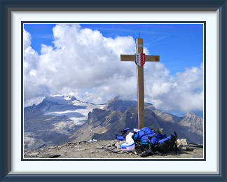
The summit had, needless to say, a cross, emblazoned with the shield of Canton Bern on one side and that of the Valais on the other, since it lies on the border between the two. This cross is not particularly old, having been erected only a couple of months before I last stood on this summit in 2008. Here it is from back then, with its timber fresh, and a rather better view of the Diablerets than I was getting this time. Growing cumulus and summer haze meant that distant peaks were hardly visible, but the local views were perfectly satisfactory, like that to the Wildhorn (of which more later). The summit and its northern shoulder also afford great views down to the Sanetsch Pass and the road which terminates at the Sanetsch Reservoir, here also in a photo taken years ago.
Our descent was by the same route we had taken on the way up, with a little more fun threading our way through the Geltenbach's braids before we came over the top of the step and could see the Gelten Hut in gathering gloom below. As we reached the hut, the first raindrops were falling, and we had to retreat inside from the terrace as a deluge of thundery hail and rain descended. We nursed beers for the best part of an hour until it finally slackened off and we could continue. Now the once silvery streams were swollen and brown, and formerly dry and unremarkable parts of the path had acquired water features which fortunately didn't hold us back much. Back at the car, we reflected that if we had been half an hour later on the descent, we might well have been trapped amidst those braids of the Geltenbach in spate.

The Garde de Bordon is a mountain in the Pennine Alps in the canton of Valais. It lies between Zinal in the Val d'Anniviers and the Lac de Moiry reservoir. Access from the dam is via a somewhat roundabout route taking in the Corne de Sorebois peak to its north, followed by about three kilometres along the crest of the range to the summit. Direct descent to the upper end of the reservoir is possible down the trackless but not dif ficult Comba Rossa valley.
 The full-blown heatwave had bowed out a couple of days after the last walk,
not with the forecast phalanx of thunderstorms and heavy rain, but with sporadic
thunder at odd hours and brief periods of rain, followed by a descent to still
quite warm conditions and rather more cloud than of late. After six days, conditions
were more settled, and a fine day was forecast. It was time to get out again.
The full-blown heatwave had bowed out a couple of days after the last walk,
not with the forecast phalanx of thunderstorms and heavy rain, but with sporadic
thunder at odd hours and brief periods of rain, followed by a descent to still
quite warm conditions and rather more cloud than of late. After six days, conditions
were more settled, and a fine day was forecast. It was time to get out again.
The warm summer meant that higher peaks would be in good condition; there were still plenty to do in the Valais. The Garde de Bordon looked as good as any, though it was a long way away. I was duly on my way at 05:30 for the journey down the motorway past Montreux and Martigny to Sierre, where the mountain road up the Val d'Anniviers led to Grimentz and the Lac de Moiry reservoir. Here there were plenty of free parking places, no doubt occasioned in part by the restaurant located right beside the dam. It was just after eight when I arrived, and the temperature was a refreshing 7°C. The plan this time was to traverse the Garde de Bordon by first heading north to the gentler summit of the Corne de Sorebois, then south along the long ridge to the Garde itself and finally down its south-west ridge to the end of the motorable road some distance to the south of the Lac de Moiry.
The path to the Corne de Sorebois was a perfectly conventional ascent through steep cattle pastures to a rounded and still partly grassy top, much scarred by ski facilities on the other side. From this part of the walk, there were fine views of the Moiry dam and the car park far below. Just along the ridge from the Corne, the way was barred by a half-hearted fence with a warning about work in progress. Though heavy machinery had clearly been there quite recently, there was nobody around and I ignored it. The early part of the ridge had scraps of plausible-looking path, but as I continued, it became harder to join them up, and there were no markings. At the first big tower, there were instead ropes. Why they had been installed wasn't entirely clear; most of the way could be done without them. Between the fixings they had too much slack for a safe hold, and in some places, oddly insecure knots looked capable of provoking an accident if they unravelled.
The crux of the walk came a little later. A faint track led across scree to some near-vertical towers, where a couloir behind the nearest one offered a way through. The steep interior of the couloir was made all the harder by the cold, muddy shale covering every hold; even quite big stones were ready to head for the valley at a moment's notice. It was only when I was nearing some more ropes at the exit from the couloir that a faint noise below told me that I wasn't alone; luckily I hadn't sent any debris down on my follower's head.
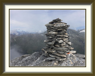
The rest of the ascent was a straightforward slog over scree slopes to the summit, where the Cairn Fairy had put in a decent bit of work. Despite the rising cumulus which had persisted since morning, there were some great views. The Garde is one of the best viewpoints for the Weisshorn, for example.
All around the summit, I had been noticing freshly-laid air hoses and strange objects like giant inverted tobacco pipes. I had passed a similar object years before on the Oldenhorn and idly wondered what it was. A hairdryer for ibex? A device for calling Teletubbies home? Looking at several here, it dawned on me... avalanche blasters! Propane and oxygen are fed on command from a nearby control box into the downward-facing pipes and ignited by a spark. The resulting explosions haven't got enough brisance to shatter the pipes, but make quite enough of a blast wave to set loose snow in motion.
The guy in the couloir was nowhere to be seen, but there was a group of three French Swiss walkers on the summit and we fell into brief conversation about the mountain. After they had set off along the south-west ridge they had ascended, I had a leisurely lunch before heading down the same way. The first part of the descent was along the easy ridge to a small cairn at the point where it was necessary to abandon the ridge and head straight down the slope. The scree here was unmarked, but fortunately easy. Gradually the grass reasserted itself, but there was still nothing like a track. When I wasn't watching my footing, there were fine views from this side of the mountain of the Moiry Glacier and the distant Cabane de Moiry perched above it. I encountered the French Swiss stopped for a snack here and exchanged a few words before hurrying on. Not far above the valley, I spotted them below me once again; they had obviously found a quicker way. Heading for the end of the road just as I was, they disappeared along a promising-looking path following the contour northwards, but I opted to do the last bit straight down the now easier slope. Amusingly, they rounded a bend just in front of me when we were barely above the road. After general laughter at these "stupid" paths1, they offered me a lift in their car, saving me the longish and unrewarding walk along the road the whole length of the reservoir back to the dam.
The tiny Silberhorn Hut belongs to the Lauterbrunnen Section of the Swiss Alpine Club. It lies at the foot of the Silberhorn, a subsidiary summit of the Jungfrau, the ascent of which is a dif ficult mountaineering enterprise. Access is via one of the more challenging hut tracks in the Alps, long, varied and quite exposed in places.
 The four days since the last walk had not been perfect, with modest amounts of rain on
two, but there continued to be plenty of sunshine and temperatures remained
well above average. Even the highest paths would be in excellent condition, but I
didn't feel like another monster drive to the Rhône Valley to reach one of
the many 3000ers left there. Casting around for something nearer, I couldn't think
of a single peak in the Bernese Oberland of a suitable height. There was, however,
one hut with a notably long and difficult track which I had last done twenty five years
to the day before. Apart from refuges accessible only to climbers, the Silberhorn Hut
on a shoulder of the Jungfrau has one of the longest and hardest approaches of any in
the Swiss Alps. That would be worth trying again.
The four days since the last walk had not been perfect, with modest amounts of rain on
two, but there continued to be plenty of sunshine and temperatures remained
well above average. Even the highest paths would be in excellent condition, but I
didn't feel like another monster drive to the Rhône Valley to reach one of
the many 3000ers left there. Casting around for something nearer, I couldn't think
of a single peak in the Bernese Oberland of a suitable height. There was, however,
one hut with a notably long and difficult track which I had last done twenty five years
to the day before. Apart from refuges accessible only to climbers, the Silberhorn Hut
on a shoulder of the Jungfrau has one of the longest and hardest approaches of any in
the Swiss Alps. That would be worth trying again.
It was a drive of about eighty minutes to reach the capacious but chargeable car park at Stechelberg at the end of the public road through the Lauterbrunnen Valley. The track begins a little further up the no longer public road, and the first thing along the way is a rock with memorial plaques for climbers. A reminder to be careful? The first two hours and a bit were spent on the familiar track more commonly used to reach the Rottal Hut. About 1100 metres above Stechelberg, the easy part of the journey ends at a place called "Bim Chalten Brunnen", where a boulder with faded paint marks the turn-off from the Rottal track. From here, bits of the exiguous track can just be discerned as it crosses what I came to think of as the amphitheatre, a curved and very steep slope beneath the outer cliffs of the Jungfrau. Traversing this to the little patch of grass on the left skyline is not technically demanding, but there are many places on the way where a fall would be fatal.
Around the shoulder of the mountain, the track entered somewhat less steep ground, before ascending a couloir with a longish chain. A quarter of a century earlier, there was no chain and the couloir was more of a challenge. There followed a considerable stretch where grass and loose stones fought for supremacy and the track was only inches wide. Beyond the last of the grass, the route traversed the Strahlplatten, an unusual apron of bare rock at the foot of the Fellenberg cliffs. After endless loose stones, it was a pleasant change to have smooth rock underfoot. It wasn't long, however, before big rubble resumed, with the consolation that at last the hut was visible on the saddle between the Rotbretthorn and the Silberhorn, a subsidiary peak of the Jungfrau. Say what you like about the quality of the terrain approaching the hut, it was well marked. The saddle was protected by a band of slightly overhanging cliffs needing chains and a ladder to overcome them, before the last easy stretch to the hut.
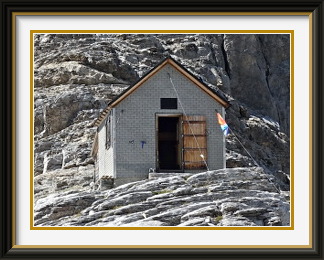
The wardenless Silberhorn Hut was perched at the foot of the little Rotbretthorn, looking exactly as I remembered it from long ago. The tiny hut has bunk bedding for just twelve people, with a small dining area and the basic facilities neatly packed into one corner. The hut serves only fairly demanding routes up the Jungfrau, done a few times a year, but I was not alone. A young American couple had walked over from the Rottal Hut to spend the night, and a Swiss couple who had carried their paragliders up didn't stay long before floating off. A helicopter landed briefly on the saddle to deliver what looked like cartons of soft drinks. None of this distracted from an unconventional but splendid view of the Eiger and Mönch beyond the seracs of the nearby Giessen Glacier.
After an hour and a half soaking in the sights, I set off back the way I had come, down the ladder and over the boulder fields to the slightly weird bareness of the Strahlplatten. In the late afternoon, the amphitheatre looked prettier than ever, but it wasn't the place to indulge in sightseeing; some parts of the journey across it absolutely do not allow stumbling. This bit of the route was protected by a loose chain and a piece of very thin cord, to which I certainly wouldn't entrust my weight. Back at the junction with the Rottal track, there was time for a rest and a snack before the long and unexciting walk down to Stechelberg.
Le Métailler is a mountain in the Pennine Alps in the Canton of Valais. It lies between the Nendaz and the Héremence Valleys. The easiest approach is from the Grande Dixence dam if the start of the path can be found; the upper slopes are largely trackless.
 After a break of nearly two weeks occasioned by a visit to Ireland, followed almost
immediately by the first incursion of significantly cooler weather since we arrived,
I needed to get one more walk in for the month. The cool air from the north-west followed the
usual infuriating practice of just raining harmlessly on the heights (...and raising hopes),
until it suddenly ended with a dumping of snow down to 2000 metres just before being driven
out by the return of a more seasonally appropriate high. Peaks on the northern side of
the Alps would be out of bounds until the snow melted; it would be necessary to go
to the Valais again.
After a break of nearly two weeks occasioned by a visit to Ireland, followed almost
immediately by the first incursion of significantly cooler weather since we arrived,
I needed to get one more walk in for the month. The cool air from the north-west followed the
usual infuriating practice of just raining harmlessly on the heights (...and raising hopes),
until it suddenly ended with a dumping of snow down to 2000 metres just before being driven
out by the return of a more seasonally appropriate high. Peaks on the northern side of
the Alps would be out of bounds until the snow melted; it would be necessary to go
to the Valais again.
A search of guide books and online sources turned up Le Métailler as a suitable candidate, and I was once again up early and off by 05:30 for the two hundred or so Km. to the parking place at the foot of the Grande Dixence dam, whose enormous bulk soared nearly three hundred metres into the sky behind. The track led off from the extreme end of the parking facilities, with an empty signpost to guide me on my way. The only description of the walk I had read indicated that the path would descend through bush for a while before beginning to rise again. And indeed, it did descend without markings of any kind. With no indication of when the descent should stop, I continued down a stony watercourse until I saw a modest track leading across the slope. This led through thick, woody bush and across steep grass before petering out. Retracing my steps, I found another half-hearted trail which did the same thing. This notice in the middle of a patch of dense, young forest was the only one around. Weird... there was no stream or even dry watercourse nearby. I reckoned that if I continued far enough along the contour, I would eventually get to a decent-sized gully that might serve as access to the heights, but when I finally reached one, it was too steep and choked with growth to be practicable. Another eternity of bashing across terrain like this followed, with occasional forays straight up the slope to attempt bands of rock, but all were protected by impenetrable vegetation. After some hours, there was no longer any hiding from the fact that I would not be seeing Le Métailler after all. Not only that, but it would likely be an expedition to get back to the car park, since I had taken such a random path to get to where I was.
Luckily, the road was clearly visible hundreds of metres below, so when all hope was gone, I just bashed my way straight down the slope through thigh-deep shrubbery and grass. Looking back up my escape route, I reflected on the biggest farce in quite a few years of hillwalking. Not only had I failed to reach the peak, I had never even risen above the altitude of my starting point. It could have been worse... no cliffs invisible from above blocked my descent, and thrashing around in this sort of terrain is great exercise for the knees. Walking back up the road, I stopped to eat my sandwiches by a signpost for the track down the valley. I noticed that one of the signs had been removed, and from the angle of the clasps left behind, it must have pointed diagonally across the road and uphill towards the dam. A quick sortie revealed that there was indeed such a path, with no indication that it was blocked by landslips or anything else. Along with the empty signpost at the start of the day's efforts, it made me wonder if there was some effort to discourage walkers in this part of the valley. In any case, I stayed on the road for the rest of the journey.
Back at the dam, the path down is signposted, but the relevant walk times are exactly the same as on the first one, 240 metres lower down. Clearly something has been bungled. While photographing the tracks around the dam, I noticed that the distant Wildhorn and its Bernese neighbours seemed less distinct than they should in such clear weather; a faint brown haze surrounded them. It turned out to be smoke. We think it remarkable in New Zealand when we get a smoke haze from forest fires in Australia, but this was from British Columbia, a good eight thousand kilometres from Switzerland!