


Munt Pers is a mountain in the Bernina Range of the Rhaetian Alps in the canton of Graubünden. It can be reached from the Bernina Pass road via a fairly easy path, or via the Diavolezza Cable Car, which accesses a saddle not far from the peak. Both the saddle and the peak are magnificent viewpoints for the high peaks of the Bernina Range, including Piz Bernina, the easternmost 4000-metre summit in the Alps, and also for the big glaciers flowing down from them.
 With the rather cold September of 2017 in mind, we came early enough
in July to get a reasonable quota of walks done, even if this year's
September should decide to be moody also. Up to the time of our arrival,
the summer had been one of the hotter ones, so
it was possible to start walking fairly high peaks straight away. To
kill two birds with one stone, I decided to take the wife camping
in the Engadine. The days not used for walking we could use to drive
around a part of Switzerland we hadn't seen for years,
and there would be an endless supply of new peaks to
try. A camping ground on the outskirts of San Moritz was just the
ticket. At nearly six thousand feet, the 32°C heat of the plains
would be replaced by something more like 20°, though the early
hours might well be as low as five.
With the rather cold September of 2017 in mind, we came early enough
in July to get a reasonable quota of walks done, even if this year's
September should decide to be moody also. Up to the time of our arrival,
the summer had been one of the hotter ones, so
it was possible to start walking fairly high peaks straight away. To
kill two birds with one stone, I decided to take the wife camping
in the Engadine. The days not used for walking we could use to drive
around a part of Switzerland we hadn't seen for years,
and there would be an endless supply of new peaks to
try. A camping ground on the outskirts of San Moritz was just the
ticket. At nearly six thousand feet, the 32°C heat of the plains
would be replaced by something more like 20°, though the early
hours might well be as low as five.
Settled comfortably in the campsite, we were able to take a day trip to the customs-free village of Samnaun at the other end of the Engadine and to appreciate just how splendid the scenery is for much of the way. Then it was time to begin the first walk. I relished the luxury of having to drive for only a few minutes to reach the (free) parking place at the valley station of the Diavolezza cable car on the Bernina Pass road.
The path began as a jeep track leading from the adjacent Bernina railway station and skirting the northeastern ridge of Munt Pers. The predominantly grassy terrain lasted as far as the little Lej da Diavolezza, where the course of the cable car was visible far above. Shortly afterwards, the grass faded out, and the rest of the way up to the upper cable car station was over slightly rougher ground. The track broke out onto the saddle a little to the west of the cable car, where there was a good view of Munt Pers beyond the Diavolezza Station. The restaurant's terraces are the pre-eminent place from which to view the Bernina Range; Piz Bernina itself, the easternmost 4000er, rises above the Morteratsch Glacier, but pride of place goes to the shining icefalls of Piz Palü and the great curve of the Pers Glacier carrying their output away.
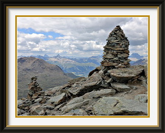
The summit of Munt Pers is only about two hundred metres higher than the station, so it is something of a tourist excursion, and indeed the great majority of walkers make the trip this way. Nevertheless, this part of the track was no place for high heels. It became briefly steep and blocky before a last, easy stretch to the summit. There was, of course, a small crowd on top, and it was only when all had departed that I could take a photo of Munt Pers's summit cairn with a background of Graubünden peaks.
The cable car station and the peak have been well clear of snow since at least 1991, but my 1970 copy of the LK of the Upper Engadine shows the bowl below the station under permanent snow for about the first hundred metres down. Now, in a last desperate effort to preserve something of the original, the ski operators have set to work and the upper parts of their pistes survive the summer under sleeping bags. How long before even this kind of cover can't rescue the snow?

Piz Blaisun is a mountain in the Rhaetian Alps rising above the eastern side of the Albula Pass road. Access from the road is via the Chamanna d'Es-cha (Kesch Hut) track and the Pischa Valley. The last part of the ascent from the Fuorcla Pischa is monotonous and steep. The summit has fine views of nearby Piz Kesch (3417 M.) and a seemingly endless sea of Graubünden summits in all directions.
 The near-perfect weather continued. Two days after the last walk, the worst the
forecast could promise was decorative cumulus clouds building up during the afternoon,
and temperatures remaining high; the decision to walk again was an easy one. There
were probably a dozen suitable peaks within half an hour's drive of San Moritz.
With the idea of gradually increasing the difficulty as I grew more fit, I chose
the still fairly easy option this time of Piz Blaisun near the Albula Pass road.
The near-perfect weather continued. Two days after the last walk, the worst the
forecast could promise was decorative cumulus clouds building up during the afternoon,
and temperatures remaining high; the decision to walk again was an easy one. There
were probably a dozen suitable peaks within half an hour's drive of San Moritz.
With the idea of gradually increasing the difficulty as I grew more fit, I chose
the still fairly easy option this time of Piz Blaisun near the Albula Pass road.
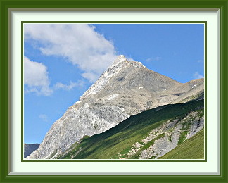
After another deliciously short drive from San Moritz to La Punt and up the pass road, I parked at a spot called Punt Granda, bereft of buildings and notable only for the fact that the path began there. The roadside parking was already nearly full, but a steady stream of walkers returning to their cars ensured that little waiting was necessary. At first, the track slanted up the slope back the way I had come, with a view of Piz Blaisun and Piz Üertsch in the morning sun. Crossing over the saddle called the Fuorcla Gualdauna into the Es-cha Valley, a long, horizontal stretch of the path circled the head of the valley towards the hut called the Chamanna d'Es-cha at the foot of the Val Müra Chain.
A little further on, before the path had begun to climb again, it crossed a gentle rubble slope, where what could best be described as mad cairn disease had broken out. The emphasis was certainly on quantity at the expense of quality. How long before the entire slope has been converted into cairns? Just after that, the path crossed the stream draining the high Pischa Valley with the first view of Piz Blaisun from the northern side. Looking back the way I had come, there was a beautiful view of the distant Bernina chain under summer cumulus. The weather would remain like that all day.
The way to the peak left the gentle path to the hut and turned sharply up the slope into the Pischa Valley, where Piz Blaisun came more clearly into view. In the increasingly stony terrain, after the last grass had faded out, the cairn fairy had been at it again. Some of the efforts were quite stylish, but some were not really proper cairns at all. The mixture of colours in the stones here results from the fact that nearby Piz Kesch consists of crystalline rock containing iron, whereas Piz Blaisun is calcareous.
The marked track led across the Fuorcla Pischa, the saddle at the head of the Pischa Valley, into the Plazbi Valley. To reach the summit, a much fainter track led more than three hundred metres up steep scree slopes, somewhat tiring, but not particularly difficult. At the top, there were the usual summit cairns, along with a view which is of a quality rather less pedestrian. The distant views were interrupted only by nearby Piz Üertsch, not an easy walk, and Piz Kesch, one of Graubünden's finer middle-height peaks. The weather remained delightful as I munched my sandwiches, alone most of the time.
Piz Ot is a mountain in the Albula region of the Rhaetian Alps. Steep-sided and pyramidal, it is the highest point in its neighbourhood, and commands views of an enormous number of near and far summits, allegedly even the Aletschhorn in the Bernese Oberland, some 140 Km. away. Recommended for those without their own transport, as the most commonly used track begins right outside Samedan railway station in the Upper Engadine.
 The near-perfect weather continued, not in the sense that the sunshine was unending,
but rather that, when a disturbance arrived, the showery rain was over and done
with in a single day. Happily, it was one when we had planned to do other things anyway.
The third day after the last walk dawned with a promise of the same light, friendly
cumulus we had seen so much of recently. It only remained to choose one of the many
substantial hills still to be done in the vicinity. I could quite literally have
walked out of the campsite and up Piz Surlej nearby, but I settled on the somewhat
better known Piz Ot instead. All that was required was to drive the short distance
to Samedan and park in the railway station, where a blue Wanderweg sign told me that
the walk was (a) slightly difficult and (b) popular.
The near-perfect weather continued, not in the sense that the sunshine was unending,
but rather that, when a disturbance arrived, the showery rain was over and done
with in a single day. Happily, it was one when we had planned to do other things anyway.
The third day after the last walk dawned with a promise of the same light, friendly
cumulus we had seen so much of recently. It only remained to choose one of the many
substantial hills still to be done in the vicinity. I could quite literally have
walked out of the campsite and up Piz Surlej nearby, but I settled on the somewhat
better known Piz Ot instead. All that was required was to drive the short distance
to Samedan and park in the railway station, where a blue Wanderweg sign told me that
the walk was (a) slightly difficult and (b) popular.
The first challenge was to find the right path through Samedan's narrow streets onto the slopes above; this can be a problem in bigger resorts like Grindelwald, but luckily Samedan is small enough that getting lost isn't very likely. Soon I was looking down on the town's rooftops in the morning mist. There followed a short slog up a typical woodland path towards Alp Muntatsch before the track turned west into the Valletta, an upland valley still green enough to support a few summer cows. The grass faded out to be replaced by the usual stony wilderness, and at a fork in the track, there was a large boulder with "Piz Ot" written on it. Unfortunately, it didn't indicate which way to go! I took the right fork, guessing that the left one was for the saddle called the Fuorcla Valletta at the head of the valley. The white-blue-white paint marks were no longer in evidence, replaced only by a few desultory cairns, but after less than a kilometre hacking my way over easy boulders, I suddenly found myself back on a marked track once again. Later inspection of the maps showed a second fork higher up the valley; the first one seemed to have been deprecated, so to speak, but nobody had bothered to remove the marked boulder. No harm.
Around here there were the first good views of Piz Ot far above. As the track approached the base of the summit, the markings were a help in finding the easiest way through the wilderness of smashed rock when the occasional other walker above didn't provide a clue. On the steepest parts of the final ascent, where loose boulders could not hold their grip, sporadic chains provided a measure of reassurance.
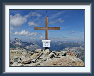
Higher than anything else nearby, Piz Ot's comfortable summit had splendid views in all directions. To the left of the cross in the picture is Piz Ela, one of Graubünden's less walkable summits, but in the other direction the icy Bernina summits were still as visible as they had been for almost the whole sunny week. As I was still not fully fit, I had reached the top rather late, and there was nobody else there, so I had a peaceful lunch snack looking down the precipitous slopes to the little Suvretta Alp in the Val Bever far below.
The weather held as I retraced my steps, and on the descent past Alp Muntatsch, there was a fine view down to Samedan and the peaks along the Bernina Road in the mild late afternoon light.