


The Brisen is a mountain in the Urner Alps on the border between the cantons of Nidwalden and Uri. Access is from the settlement of Niederrickenbach, high above the Engelberg Valley, off the Swiss road network and best reached by cable car. The peak commands fine views from Lake Lucerne to the main chain of the Alps. Its marginally higher neighbour, the Hoh Brisen, is significantly harder to reach.
 Since the farce on Le Métailler at the end of August, a second, more
serious cold snap had hit the country. There had been several dull and cold
days on the plains, with afternoon temperatures as low as 15°C. Then two
days of gradually improving conditions gave some grounds for optimism; there
would be no point in aiming for great heights, but peaks up to two and a half
thousand metres would be unlikely to present problems.
Since the farce on Le Métailler at the end of August, a second, more
serious cold snap had hit the country. There had been several dull and cold
days on the plains, with afternoon temperatures as low as 15°C. Then two
days of gradually improving conditions gave some grounds for optimism; there
would be no point in aiming for great heights, but peaks up to two and a half
thousand metres would be unlikely to present problems.
With little left to do in the Bern or Fribourg Prealps, I looked eastwards. It was necessary to look quite a long way before I found something appealing enough... the Brisen above the eastern side of the Engelberg Valley. Though it was on the other side of Lucerne, the drive would still be considerably less onerous than the marathons into the Valais; I would only have to set out around eight in the morning.
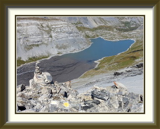
It took an hour and three quarters to get to the car park of the Niederrickenbach cable car in Dallenwil. Then, in a rare departure from practice, I took the cable car up to Niederrickenbach. It would have been perfectly possible to get there on foot, but about half of the distance to the settlement some 650 metres above would perforce be along a road, so I judged that it just wasn't worth the time and effort. At the upper station of the cable car, there was an example of the sort of monster signpost so typical of central Switzerland. Though Niederrickenbach, a place of pilgrimage, is not attached to the main Swiss road network, it does have a few surfaced roads, and there was no escaping asphalt at the beginning of the walk. Soon, however, it gave way to a jeep track, from which there were some fine views of the Brisen managing to look surprisingly imposing for its modest height. With the jeep track and most of the forest left behind, the path ascended the grassy slopes below the Brisenhaus, where large numbers of exposed stones and frequent cowpats did not enhance the experience.
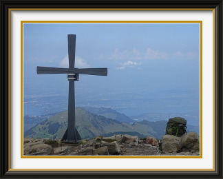
The hut called the Brisenhaus has some fine views towards peaks like the Pilatus. After it, the path became more alpine, though never difficult, but the terrain only really started to be interesting on the way to the saddle just to the south of the Brisen's steep summit. Here the tilted strata of which the peak is composed were very obvious. A short, steep stretch led from the saddle to the summit, where a somewhat characterless metal cross looked out over Lake Lucerne in the haze. Rising cloud hid most of the main alpine chain, but not the nearby Hoh Brisen, with its strange wood grain textures.

The Pigne de la Lé is a mountain in the Pennine Alps in the canton of Valais. It lies south of the Lac de Moiry in the valley of that name off the Val d'Anniviers. It commands excellent views of some of the giant Pennine peaks like the Weisshorn, as well as over the Moiry Glacier below.
 The harmlessly cloudy conditions of the last walk had ceded the stage to
warm and very sunny weather a few days later. While there would undoubtedly
be residual fresh snow above 3000 metres, time was running out and there was
no guarantee that waiting would improve matters. As so often late in the season,
the best policy would be to head for the Valais, where the impact of cold
fronts is often blunted by the ranges to the west and north. But what peak
to choose?
The harmlessly cloudy conditions of the last walk had ceded the stage to
warm and very sunny weather a few days later. While there would undoubtedly
be residual fresh snow above 3000 metres, time was running out and there was
no guarantee that waiting would improve matters. As so often late in the season,
the best policy would be to head for the Valais, where the impact of cold
fronts is often blunted by the ranges to the west and north. But what peak
to choose?
Here I had help from an unconventional quarter. Barely a week earlier, I had visited a work colleague from the eighties. Over a delicious fondue prepared by his wife accompanied by wine from their own vineyard, the conversation turned to the reasons why I returned so often to Switzerland, and walking figured large in my reply. It turned out that he had once upon a time been a walker too, something I had not known at the time. Among the peaks mentioned was the Pigne de la Lé, one I had not read about anywhere. As it was in the right area, and as I had no other strong candidate in mind, that was enough to tilt the balance in its favour. Also, I had for once no official indication of its difficulty level, so that would add a little spice to the experience.
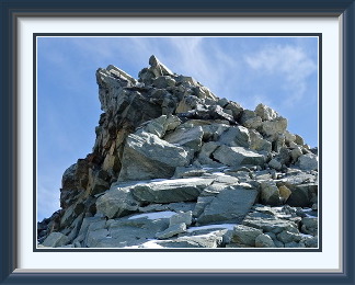
So it was that after the usual five thirty start, I arrived in the capacious free parking above the Lac de Moiry, just the spot from which I had gotten a lift back to the dam from the friendly French Swiss after we had all come down from the Garde de Bordon a month earlier. The path began easily enough over the last of the summer cattle pastures, before using an old lateral moraine to gain height and ascending in standard hairpins. After the end of the grass and the beginning of the rubble field the new wing of the Cabane de Moiry commanded a splendid view across the valley in the clear morning light. Here the white-red-white markings ended, to be replaced briefly by white-blue-white before the latter were replaced in turn by sporadic unconventional marks on the way up steepish boulder fields to the Col de la Lé. At 3137 metres, this represents the end of the road for most walkers, and already offers great views of peaks to the east and the west. Just to the north, the nearest of the Aiguilles de la Lé sported a cross barely fifty metres higher.
On the other side of the col, the Pigne itself loomed somewhat dauntingly skywards. The route to the summit lay along the ridge all the way; the recent snow preserved by its northern aspect would require care, and it would be necessary to skirt occasional gendarmes1. In the event, the snow had hardened but not become icy, so it was easy to walk on, and very occasional boot prints showed where past walkers had been. For most of the time, the steep terrain on the ridge was quite enjoyable to traverse. Once, however, when getting around a gendarme, a deceptive boot print tempted me quite far along a snowy terrace on the east face of the mountain until progress became impossible and I had to scale extremely steep rocks to get back on the ridge. It was only on the descent that I could work out the correct way.
Between the mountain's twin summits lay a small permanent snowfield which had to be crossed to reach the highest point. Fortunately it had not iced up. No cross here, nor summit book, but the uninspiring summit cairn did command some impressive views, like that over the Zinal Glacier tongue to the Obergabelhorn and the distant Matterhorn. Nearby, the surprisingly big Moiry Glacier flowed down from the slopes of the Grand Cornier while, far below, the Cabane de Moiry looked out over the glacier tongue and its old moraines. I munched my sandwiches in mildly surprised solitude, for I had glimpsed figures far above from the col and assumed I would have company; they must have been intent on crossing the glacier to the somewhat higher peaks opposite. As I ate, I watched a paraglider sail past, launched from god knows where.
After a comfortable hour on the summit, I set off down the ridge. Back on the terrace of the original part of the Cabane de Moiry, the weather had held and the Pigne was still visible above. Looking the other way, I could see down the slope to the path over the Moiry Glacier's old moraine to the car park in the distance.
The Wildhorn, situated on the border with canton Valais, is by a narrow margin the tallest mountain in the Western Bernese Oberland. It is a popular climb from If figenalp and the Wildhorn Hut via the Tungel Glacier, a trip requiring glacier equipment. However, snow-free access from the Sanetsch Pass via its steep western cliffs is now possible in late summer.
 Far from cooling down as one might expect, the weather in the days since the
last walk had become steadily warmer until temperatures on the plains were
approaching record levels for September. Though the snow which had fallen around
the start of the month would still be filling shaded pockets on the less sunny
sides of the higher peaks, experience on the last walk indicated that it
would be manageable. I could go high again.
Far from cooling down as one might expect, the weather in the days since the
last walk had become steadily warmer until temperatures on the plains were
approaching record levels for September. Though the snow which had fallen around
the start of the month would still be filling shaded pockets on the less sunny
sides of the higher peaks, experience on the last walk indicated that it
would be manageable. I could go high again.
There was one mountain I had had my eye on for a long time. The Wildhorn was the first glacier ascent I had ever done. Exactly forty years earlier, a group of us from work had stayed overnight at the Wildhorn Hut and made the standard ascent via the Chilchli and Tungel Glaciers. That wasn't what I wanted to do now, however; for a start, the shrunken glaciers have become more, not less, dangerous. No, the thing to do would be to ascend from the western side, where the mountain ends in a band of cliffs and any glaciation has all but disappeared. The walking would be much more difficult, but crampons and rope would not be needed. Unfortunately, it would be necessary yet again to drive all the way to Sion in the Valais to get to the roadhead on the Sanetsch Pass.
A five a.m. start allowed some leeway in case the little-used road up to the pass took longer than I hoped. In the event, the 200-Km. journey went off without a hitch and I was at the car park at the highest point of the road by half past seven. A couple of maintenance workers were doing something in the little workshed across the road while I had a quick breakfast, but there was nobody else around as I set off a little after eight. The first part of the walk proceeds up a series of rounded humps, and from the highest of these there was a fine view across the pass in the morning sunshine to the Diablerets and the Tsanfleuron Glacier opposite. Here a blue track continued to the Arpelistock, but my red path turned east, and for several kilometres descended gently across mixed alpine grass and stony stretches to some tarns at a place called the Grand Gouilles. Just past these, I left the path for good and headed up a trackless valley to the Gelten Pass. Here was evidence that the army had been littering, though there had been no signs warning of a firing area on the way. Who was doing the tidying up?
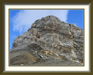
From the Gelten Pass, a broad shoulder led up to the Wildhorn's summit cliffs, steepening as it went. Here, there were once again traces of a path, but no waymarks whatever. Where the stones rested on a bed of fine, damp sludge, the path trace was clearly visible even from a distance, testament to the fact that it takes remarkably few walkers to wear an identifiable trace into even quite coarse terrain. At the foot of the cliffs, I was now faced with a problem; the only guide I had found about the route said "traverse a few metres to the left to a steep couloir which permits further ascent". In front of me was not so much a couloir as a great gash in the vertical cliff, big enough that a few metres either way made little difference. As there was nothing else around, I headed up its steep bands and terraces, everything covered with loose stones which departed for the valley at the slightest provocation, until I faced a vertical wall above, clearly not walkable. A traverse to the right reached a vertical drop into a snow-filled bowl, and to the left were rock slopes that were just too steep. I made my way carefully back down to the foot of the cliffs and made a more determined search in both directions. To the left, the cliffs showed no sign of relenting, and to the right was the snow-filled bowl. It had to be the couloir.
Somewhat exasperated, I made my way back up to my previous highest point and looked around carefully. I couldn't see the base of the vertical wall above, so I scrambled up another band and found a terrace hard against it, invisible from below. I followed it to the right... that snow-filled bowl and its sheer walls again. I followed it to the left and it rose in a gentle curve along the wall until there it was... a cairn, the only one between the pass and the summit. This cairn stood at a corner around which was the escape route into another couloir leading to the summit ridge. At last I knew where I was going. At the exit from this couloir was a boulder with a crude wire belay, the only other sign apart from the cairn that anyone ever passed this way.
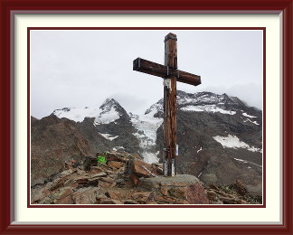
On the ridge at last, the the Wildhorn's summit was visible ahead and the difficulties were over. Within a few minutes, I was sitting alone by the summit cairn enjoying the magnificent view in all directions. The plentiful cumulus only served to bring the scenery into even greater relief. Nearby was the Wildhorn's lower summit; it's the one with the cross for some reason, and the one which garners the most visits via the Wildhorn Hut and the glaciers. Right at the bottom of the Wildhorn's northern precipices, the Gelten Hut and the braids of the Geltenbach were catching the best of the sunshine. The hut's light-coloured roof is visible just to the right of the rightmost stream braids in the picture. Beyond the Hahnenschritthorn, the Lauenen Valley stretched northwards towards Gstaad, and on the other side of the mountain, part of the resort of Crans-Montana could be made out beyond the shrivelled remains of the Wildhorn Glacier2. Otherwise there were only peaks and wilderness in every direction.
Taken from the higher summit in August 1978, this view extends along the ridge by which I had arrived this time (but not back then) to a subsidiary peak called Mont Pucel. As can be seen in the first picture of the Wildhorn's summit above, the snow that looked so permanent forty years ago has completely disappeared. The permanent ice on the SE side now lies well below both summits. On the (rather crowded) ascent up the Tungel Glacier back then, we saw depths of ice which I doubt exist any more, though I did not see down that side of the mountain this time.
The sightseeing done, I made my way back down the couloirs, carefully avoiding a wrong turn in the lower one which would have led to yet another vertical drop. With the sun getting lower in the sky, I hurried past the tarns and all the way back to the track up the Arpelistock, its summits glowing in the evening light. In front of me, the path snaked down the humps to the car park. I arrived there at sunset not having seen another human being all day.
The Jegihorn is a mountain in the Pennine Alps overlooking Saas-Grund village in the Saas Valley. The normal track proceeds from there past the Weissmies Hut. The track is notable for the warm colour of the rock and fields of large boulders on its upper stretches. There is also a popular via ferrata on the opposite side of the summit from the track. The summit is a great viewpoint for the nearby 4000-metre Weissmies Chain.
 The exceptional September warmth had relented somewhat since the last walk, and
after a brief cool and cloudy interval, the residual cloud was forecast to hang
around the hills in east and central Switzerland, with sunshine only towards the west.
To avoid the long drive up the Rhône Valley, something near the Lötschberg
Tunnel would be preferable; the further to the east, though, the greater the risk of
finding that cloud. The Saas and Matter Valleys still had a number of walkable peaks
left, and they were about as far east as I wanted to go.
High enough to be interesting and with straightforward access from
the valley at Saas Grund, the Jegihorn looked like a promising choice.
The exceptional September warmth had relented somewhat since the last walk, and
after a brief cool and cloudy interval, the residual cloud was forecast to hang
around the hills in east and central Switzerland, with sunshine only towards the west.
To avoid the long drive up the Rhône Valley, something near the Lötschberg
Tunnel would be preferable; the further to the east, though, the greater the risk of
finding that cloud. The Saas and Matter Valleys still had a number of walkable peaks
left, and they were about as far east as I wanted to go.
High enough to be interesting and with straightforward access from
the valley at Saas Grund, the Jegihorn looked like a promising choice.
After taking the early Lötschberg train, I drove down the high Lonza Valley to the point where the road suddenly burst out onto the slopes of the Rhône Valley far below. Sure enough, the western reaches of the valley were sunny under a clear blue sky, but only just to the east the picture was utterly different. Murk and gloom enveloped the hills around Brig. This was going to be close! At the fork where the Zermatt and Saas roads separated, the peaks above the former were sharp and sunlit, but towards Saas Grund, clouds were gathering. It didn't look good. Nevertheless it was too late to change my target now.
The parking at the cable car station for Kreuzboden was chargeable, but worth it because the path to Kreuzboden and beyond started there; in any case, I doubted that I would find free parking elsewhere in Saas Grund. I set off in gloom up the pine forests. When the trees thinned near the hamlet of Triftalp, the clouds had parted enough that I could see the Alphubel across the Saas Valley, but most of the other big peaks were hidden. An hour later, I was doing the last few metres to the Weissmies Hut when rain set in. There was no option but to hang around the hut reading their collection of mountaineering books and hoping that it would clear. After a little more than an hour, the rain did tail off and the Jegihorn's strikingly coloured summit appeared fitfully out of the clouds. The path away from the hut followed the contour at first, before ascending steeply up the right-hand side of the peak until it faded away into a landscape of giant boulders. At one point, there were a few staples for assistance, but most of the time it was just a matter of picking one's way through the mist up fields of big boulders.
It was about an hour from the summit when the rain started again, now more marked than before. Normally that would have been the end of the walk, but I needed one more decent summit for the month, and time was running out. So I decided to do something I had never done before and continue over moderately challenging terrain through heavy rain. Jumping from boulder to boulder took more care than usual, but the gamble paid off, and as I was standing beside the Jegihorn's summit cross, the rain stopped for good.
The Jegihorn remained a great viewpoint despite the general cloudiness. Steeply below, the Weissmies Hut lay in the middle of a warren of walking paths and vehicle tracks, and the peak it serves popped its head out of the clouds now and then. Further to the west, I could see my ascent route from Saas Grund past Triftalp and Kreuzboden. I was not alone on the summit; there were a handful of others who, by the looks of their equipment, had come up via the Klettersteig on the other side of the mountain. I set off down more or less simultaneously with them, and the improved weather meant that there was time to enjoy the scenery as we threaded our way over monster boulders. This was a great place to admire the colourful summit of the Jegihorn once more. Presumably the rock contains a lot of iron.
Back on the more conventional path down to the cable car, the Klettersteig people were making slow progress; one of the girls was tired. The guy with her asked if I knew whether the cable car's last run was at 16:30 as he suspected. They weren't going to make that. I said no, I never use them, but out of curiosity I stopped and asked the ticket checker when they closed for the day. Sure enough, it was 16:30. Why the hell do they shut down with sunset nearly three hours away? When I mentioned that there were people a few minutes up the track needing to get down, he said, no problem, there was a "service run" at five for staff, and they could use that, but their ticket would not be valid and they would have to pay again. Better than nothing, but not terribly impressive!
The Plattenhoerner are a series of tops just east of the Gemmi Pass, named for the "Platten", sheets of smooth, bare limestone on their northern slopes. On the southern side, there are vertical dropoffs towards the Leukerbad Valley far below. The summit with the cross (the "Kreuzgipfel") is easily reached from the Gemmi Pass, but the higher tops further east are much more dif ficult.
 It was still mostly warm and sunny, and in the last week of the year's stay I had
a few days to spare. One I had filled with a day card from Swiss Railways,
using it to visit Locarno and Lugano, returning via the monster new 57-kilometre
tunnel under the Gotthard. Now the wife wanted to visit a friend, so I decided to
get out once more, but this time I would do it differently. I would go to
Kandersteg because it was an easy drive, and I would do a quick and dirty walk
with no specific target in advance. Whatever looked good and hadn't been
done in recent years would do.
It was still mostly warm and sunny, and in the last week of the year's stay I had
a few days to spare. One I had filled with a day card from Swiss Railways,
using it to visit Locarno and Lugano, returning via the monster new 57-kilometre
tunnel under the Gotthard. Now the wife wanted to visit a friend, so I decided to
get out once more, but this time I would do it differently. I would go to
Kandersteg because it was an easy drive, and I would do a quick and dirty walk
with no specific target in advance. Whatever looked good and hadn't been
done in recent years would do.
So it was that I ended up in the car park at the back of the Kander Valley. As the normal rules weren't in effect, I caught the cable car up to the beginning of the track across the Spittelmatte towards the Gemmi. The path, in parts a jeep track, led past the Schwarenbach Hotel in beautiful morning sunshine. After curving around the base of the Klein Rinderhorn (not an option for a day like this), it reached a view of the Daubenhorn beyond the Daubensee. The Daubenhorn might have been an option with more preparation, but when I arrived at the Gemmi Pass facilities an hour or so further along the shores of the lake, a nearby Wanderweg sign provided a very practical suggestion... the Plattenhörner, just an hour away.
Not quite an hour later, I was seated on the small Plattenhorn top with the cross (the "Kreuzgipfel"), the first of many along a ridge. Just above could be seen more cairns, but the way there crossed one of the typical "Platten" after which the ridge is named. Hidden in the picture, it is basically a stratum of rock (sticking out of the cliff on the other side) off which the overburden has slid, exposing the smooth stone beneath. It was easy enough to walk across this, but clambering up onto the ground beyond, I encountered sludgy rubble so steep and loose that I was more swimming than walking. I abandoned the attempt fairly quickly; it wasn't a day for that kind of effort.
Back at the cross, there was a fine view down to the Daubensee, half empty at the end of summer. Looking westwards over the Gemmi Pass, I could see the Lämmerenboden, the flat expanse of gravel on the way to the Lämmeren Hut, shaded now by the afternoon cloud rising around the Daubenhorn. The hut itself on its grassy terrace can be seen in the upper right-hand corner of the picture. A feature of the Gemmi Pass is that, while its northern approach consists of gentle slopes extending for miles, the southern side is nearly vertical. Thus the views from the Plattenhörner are precipitous, especially the one to Leukerbad, twelve hundred metres below.
Heading back along the Daubensee, the layout of the Plattenhörner was clearer. The top with the cross lay just to the right of the notch at the right-hand side of the picture, with the plate of bare rock fanning out below it. The much higher tops to the left are reachable from the track to the Old Gemmi Pass, but are fairly challenging. The rest of the journey down the easy track past the Schwarenbach Hotel passed off under the same cheerful cumulus clouds that had been enhancing the views all day, and soon I was facing the Spittelmatte and the way back down to Kandersteg. It had been an unusually easy way to end the season.