


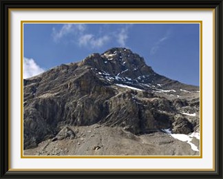
The Oldenhorn (Fr. Becca d'Audon) lies at the meeting point of the cantons of Bern, Vaud and Valais in the Western Bernese Oberland. There are several approaches, but the easiest for the walker is from the Col du Pillon Road at the Oldenegg lift. All others involve traversing ice.
 After a week in the UK and Ireland tending more towards eating and
drinking than walking, it was a bold move to resume activities with
a walk of almost 1800 metres, but there wasn't that much time left
and the Walking Friend was interested in getting high (in the
healthy sense) before I left. The usual predawn start was needed
to pick the WF up from Montreux and park at the bottom station of
the Reusch lift near the Col du Pillon. There was plenty of space,
as the lift had already closed for the winter!
After a week in the UK and Ireland tending more towards eating and
drinking than walking, it was a bold move to resume activities with
a walk of almost 1800 metres, but there wasn't that much time left
and the Walking Friend was interested in getting high (in the
healthy sense) before I left. The usual predawn start was needed
to pick the WF up from Montreux and park at the bottom station of
the Reusch lift near the Col du Pillon. There was plenty of space,
as the lift had already closed for the winter!
After the obligatory slog through the forest, the first rays of the sun touched us just below the Oldenegg, where there was a fine view of the Nägelihorn on the ridge leading up to the still out-of-sight Oldenhorn. Heading up the Oldenalp, we traversed a grassy terrace before approaching the Oldenbach stream as it cascaded over a rock step. Higher up, the last traces of grass faded away and the Oldenhorn summit came into view.
Along this part of the walk, one might think that the team maintaining the track included some gardeners, what with the neatly cut steps in the grass and, a little higher up, the border of stones delineating the path through the scree towards the pass called the Oldensattel. On the sunless and steep upper part of this scree slope, we crossed some old snow patches to find ourselves on a wide ascending terrace, clearly made with machinery. This was the first sign that we were approaching the Diablerets ski area.
From the saddle, it was a straight slog up scree slopes to the peak itself. My notes gave the saddle as being at 2911 metres, so there was barely more than two hundred metres left to do. I pressed this information on the WF as encouragement, but those last metres seemed to take forever. Oh well... must be getting old! The originally promising weather had given way to murky cloud in various directions by the time we finally reached the top, although the summit remained mostly free of mist while we were there. The neighbouring peaks were visible much of the time, but of the magnificent panorama from Mont Blanc and the Valaisian Alps to the Bernese Oberland there was nothing to be seen.
The summit was a comfortable enough place to rest, though no longer warm in mid September. It had a fine view of the Sommet des Diablerets, the only higher point in the neighbourhood, and a rather less fine view of the Sex Rouge nearby, the terminus of the cable car from the Col du Pillon, now disfigured by some sort of fairground ride.
Heading down towards the Oldensattel, we could see the tongue of the Tsanfleuron Glacier and the large area of bare rock left behind as it recedes. Although it still has more than a square mile of ice, all of it is below 3000 metres, and there must be some doubt about its prospects if climate warming continues. Back at the entrance to the Olden Valley, we passed a few isolated farm buildings at Obere Oldenalp in the early evening light. High above them on the slopes of the Schluchhorn are some odd meandering rock formations, dykes of some kind perhaps.
Reviewing the details of the walk the following day, I noticed that the height of the Oldensattel was clearly given in map and book as 2737 metres. Those final two hundred metres to the summit had in fact been four hundred. An apology had to be mailed to the WF for the cruel deception, and I never did recollect where the 2911 came from.

The Dent de Broc is a mountain in the Prealps in the canton of Fribourg. Its narrow and airy summit commands fine views over Lake Gruyère and the Fribourg countryside to the north.
 The first major cold front of the autumn had passed over Switzerland,
dumping snow down to 1600 metres in places. With the bigger peaks
quite likely off limits for the rest of my stay, it was time to
aim for more modest heights. The Dent de Broc in the Fribourg Prealps
near Gruyères would do while the snowline retreated back to
more normal levels. A quick call to the WF arranged for him to be
at Gruyères station in the morning, and we were soon parked
beside the Sense River and ready to go. To get to the start of the
real walk, we had to follow a track along the banks of the Sense
river for a kilometre or so, where there were still some old
"Toblerone" antitank barriers;
these once blocked access to every mountain valley and lakeshore in
Switzerland, but have been slowly disappearing since about the eighties.
In this case, the rest of the barriers stretching to the base of the
nearby cliffs had been dug up by the farmer and piled in an incongruous
heap in the woods. There must be tens of thousands of tons of these
concrete lumps lying around the country. Wouldn't it be possible to
collect them and sell them to some maritime country needing sea
defences?
The first major cold front of the autumn had passed over Switzerland,
dumping snow down to 1600 metres in places. With the bigger peaks
quite likely off limits for the rest of my stay, it was time to
aim for more modest heights. The Dent de Broc in the Fribourg Prealps
near Gruyères would do while the snowline retreated back to
more normal levels. A quick call to the WF arranged for him to be
at Gruyères station in the morning, and we were soon parked
beside the Sense River and ready to go. To get to the start of the
real walk, we had to follow a track along the banks of the Sense
river for a kilometre or so, where there were still some old
"Toblerone" antitank barriers;
these once blocked access to every mountain valley and lakeshore in
Switzerland, but have been slowly disappearing since about the eighties.
In this case, the rest of the barriers stretching to the base of the
nearby cliffs had been dug up by the farmer and piled in an incongruous
heap in the woods. There must be tens of thousands of tons of these
concrete lumps lying around the country. Wouldn't it be possible to
collect them and sell them to some maritime country needing sea
defences?
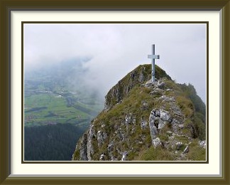
At Le Pont qui Branle ("The Rickety Bridge") a walking signpost indicated the start of the track to the Dent... and that was the last marker we saw until the saddle below the summit a thousand metres higher. Beyond the first meadow, we groped around for a while to find the start of the track proper. Once on it, progress was rapid, but I remained puzzled by the lack of markers; after all, the track was clearly marked on my LK walking map. Then I checked the map's date... 1976! We had noticed one or two mountain biking markers and I began to think that the walking track had been decommissioned.1 Nevertheless, it took us without further problems out of the forest and up steep grass of the Combes Alp, from whose upper stretches we had a good view down to Gruyères on its fortified hilltop position.
At the top of the Alp, we arrived at the saddle called the Col des Combes, from where we had a clear view of the Dent de Broc, its summit cross all too clearly visible from below. The track headed straight for the cliffs and went up the bits of grass on the right in the picture. The last part of the ascent was quite steep for a time, before we broke out onto the airy summit ridge and walked the short distance to the relatively narrow and vertiginous summit itself. The cairn fairy had given up for once, defeated by the lack of space, and the box for the summit book was welded directly to the steel cross. There was just enough space around the cross to allow sitting comfortably while having one's lunch.
As a viewpoint, the Dent de Broc was, like Monte Tamaro, a good illustration of the old adage that size isn't everything. Not only was there a splendid view down to Bulle town and nearby Broc village, but the whole of the Lac de la Gruyère could be seen stretching twelve kilometres northwards. Only the views of the neighbouring peaks were missing, blocked once again by the month's generally cloudy weather.
Given the difficulty we had in finding our way at the start of this walk, the following guide may be of assistance.
FINDING THE START OF THE DENT DE BROC TRACK
Le Pont qui Branle is at Pt. 699 on the LK, about a Km. east of Gruyères town. The lone signpost is just to the south (upriver) and a little higher. Walk a few hundred metres up a surfaced road to its end at a cluster of farm buildings called Le Châtelet. Go past it into woodland on a jeep track and almost immediately turn left. After another 200 metres and a zigzag, the jeep track ends at the entrance to a sloping meadow with no indication of a path. Cross this, tending right (upslope) until you reach a small watercourse. On the other side of this, just at the lower edge of the forest, the track is obvious and remains so from then on.
The Fromberghorn is the second peak of the long Niesen Chain, immediately to the southwest of the Niesen itself. A relatively steep-sided peak, it has no recognised tracks leading to its summit. The usual approach from the Niesen is rated T6, but an easier way along its western ridge is described here.
 The weather continued fickle. Sunny intervals were regularly interrupted
by cold fronts, bringing rain to the lowlands and lowering the snow level
repeatedly. With the level below 3000 metres even after a series of warm
days, all hope of finishing with a high walk was gone. Something lower
but interesting was needed and the Fromberghorn sprang to mind; this peak
lies immediately behind the Niesen, so can hardly be described as remote,
yet it has no marked paths at all. One of the least accessible summits of
the whole 22-Km Niesen Chain, all its flanks are steep and all its ridges
are sharp, with some having formidable steps to bar the way.
The weather continued fickle. Sunny intervals were regularly interrupted
by cold fronts, bringing rain to the lowlands and lowering the snow level
repeatedly. With the level below 3000 metres even after a series of warm
days, all hope of finishing with a high walk was gone. Something lower
but interesting was needed and the Fromberghorn sprang to mind; this peak
lies immediately behind the Niesen, so can hardly be described as remote,
yet it has no marked paths at all. One of the least accessible summits of
the whole 22-Km Niesen Chain, all its flanks are steep and all its ridges
are sharp, with some having formidable steps to bar the way.
There was another reason why I thought of the Fromberghorn. I had tried the ascent twice in previous years, only to fail each time. The first time, I was embarrassingly thwarted on the southeast (Bündiegg) ridge by pine trees whose branches reached down to the ground, and on the second try I skirted the trees and joined the ridge higher up, but finally decided that I wasn't ready to tackle the extremely steep and exposed grass slope at the top of the ridge. So there was a score to settle...
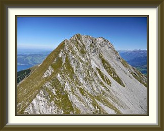
Having parked the car at the usual spot just south of Wengi, I set off up a tarred road the short distance to the hamlet of Winklen, where the track to the Niesen began. The walk up to Eggweid was a typical stretch through steep mountain forest, notable only for the farmer herding some pigs down the trail at one point. At Eggweid, I left the Niesen track and headed straight up the hill to the last farm building at Stierechummi,2 where I had the first view of the peak ahead. Through my telephoto lens, the rubble fan below the saddle to the left of the peak didn't look too bad, so I headed for that instead of the ridge. As I trudged up a mixture of grass and small boulders, I stopped to look at some oddly neat frost fractures on one piece of stone, and after about an hour the Stockhorn Chain and the lower Simmental burst into view as I reached the crest.
From the saddle, the way up the ridge was obvious, at first up the grassy apex, then on somewhat rougher ground. Soon I was on the western summit, looking along the ridge to the Fromberghorn summit, and it was only a few minutes before I threw my rucksack down beside the modest summit cairn with the box for the summit book tucked into it. Though the mountain is a popular enough target for hard cases traversing it from the Niesen, there was no one around and I ate my sandwiches in solitude.
While it lacks the grand lake panoramas of the Niesen, the summit of the Fromberghorn is still a splendid viewpoint; for a start, there is a good view of the "back" of the Niesen, with the giant hairpins of the track from the Simmental visible on the huge, even grassy slope on its southwest flank. Looking the other way, the Balmhorn and the Altels rose above distant Kandersteg. The first snows of autumn can be seen creeping down the huge, even, not-grassy-at-all northwest flank of the Altels. When I was first walking in the Oberland, this great triangular face was a conspicuous feature of the range from the west, as it kept its snows all year round while the other peaks dried out to rock and ice. Now it is bare all the way to the 3629-metre summit by the last warm days of summer; if present trends continue, what was recently a peak for mountaineers only may soon be accessible to the hardiest walkers.
Heading back down at last, I continued past the saddle and along the ridge towards the Drunengalm. It was here that I had the best general view of the Fromberghorn, but soon afterwards a big step loomed. Sunless and unmarked, it was a challenge for another day. On the track below Eggweid once again, Frutigen and the Kander Valley were framed by the trees in the early evening light.
So ended a season of indifferent weather, with more cloudy days than usual, and a rather cool finale. Despite this, I could look back on outings whose variety and challenge were undiminished. There would be other years for higher peaks.
Such information as I have seen about this peak focuses on the more difficult traverses from the Niesen or the Drunengalm. Accordingly, a guide to this easier option follows.
WALKING THE FROMBERGHORN THE "EASY" WAY
Park at Wengi, signposted off the highway south of Reichenbach. Just outside Wengi on the Frutigen side is a small lay-by between some military stores and a bridge over a watercourse; this usually has space in my experience. Walk across the bridge and up the side road to Winklen. From here follow the signposts and the white-red-white markers for the Niesen. Don't be put off - the surfaced road soon ends!
At Eggweid (signposted), the track rounds the lower part of the Bündiegg ridge. Leave the marked path here and go straight up the ridge on farm tracks, mostly quite well formed. Note that from Eggweid to the summit, the mountain has no markings whatever! Just above an old "Spycher" (wooden store) the main track veers left away from the ridge to another chalet. You can follow this, or spot a fainter track above the Spycher which stays close to the ridge before they meet again further up. At about 1700 metres, bear left past another chalet towards the Drunengalm Peak and away from the ridge. The track here has recently been improved with a digger for some distance, but becomes confusing as it approaches the last buildings at Stierechummi. If in doubt, stay near the wire of a goods lift.
At Stierechummi, you have the first good view of the Fromberghorn and the saddle to its left between it and the Drunengalm. From here, the lowest point on the saddle (Pt. 2295 on the LK) is the rightmost of three notches, each with a rockslide below it. Aim for this, going up bouldery grass at first, then along the rockslide, choosing grass or stones according to taste for much of the way. The rockslide consists of small rubble, a little tiring and slippery, but never dangerous. Exit onto the saddle is easy. T3 as far as here. Now go up the steepish southwest ridge to the west summit and on to the main summit, about half an hour in all. On the main summit is a small cairn containing the summit book. The ridge is airy at times, with steep drops particularly on the south side. Steady footing and a freedom from vertigo are essential on this part of the walk.
Return the same way. All other options are much more difficult.
Those not determined to walk every bit of the mountain from the valley may be able to find parking in or just above Winklen, but the saving in height is modest.